IMAGES TAKEN NEAR TO
Keepers Lane, PRESTON, PR3 1QN
Introduction
This page details the photographs taken nearby to Keepers Lane, PR3 1QN by members of the Geograph project.
The Geograph project started in 2005 with the aim of publishing, organising and preserving representative images for every square kilometre of Great Britain, Ireland and the Isle of Man.

There are currently over 7.5m images from over14,400 individuals and you can help contribute to the project by visiting https://www.geograph.org.uk
Image Map (Loading...)


Getting Data...Please wait
Leaflet Map data © OpenStreetMap
Images are licensed for reuse under creativecommons.org/licenses/by-sa/2.0
Notes
- Clicking on the map will re-center to the selected point.
- The higher the marker number, the further away the image location is from the centre of the postcode.
Image Listing (13 Images Found)
Images are licensed for reuse under creativecommons.org/licenses/by-sa/2.0
Image
Details
Distance
1
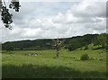
Dead tree in pastureland by Keeper's Lane
The Jubilee Cairn http://www.geograph.org.uk/photo/2980369 on Nicky Nook is just visible on the skyline.
Image: © Karl and Ali
Taken: 17 Jun 2012
0.03 miles
3
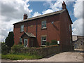
Slack Farm, Keeper's Lane
A neat, red brick farmhouse with a 1906 date stone.
Image: © Karl and Ali
Taken: 17 Jun 2012
0.07 miles
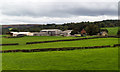
4
Farmland at Barnacre
Looking down to Slack Farm. The land hereabouts starts to rise towards the Bowland Fells so the view westwards is across the Fylde plain.
Image: © David Medcalf
Taken: 22 Jan 2006
0.12 miles
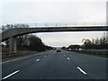
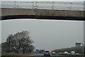
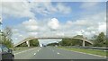
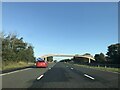
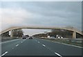
6
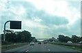
Gantry and Footbridge - M6 Lancashire
Image: © Anthony Parkes
Taken: 8 Sep 2012
0.17 miles