IMAGES TAKEN NEAR TO
Fairfield, PRESTON, PR3 1JW
Introduction
This page details the photographs taken nearby to Fairfield, PR3 1JW by members of the Geograph project.
The Geograph project started in 2005 with the aim of publishing, organising and preserving representative images for every square kilometre of Great Britain, Ireland and the Isle of Man.

There are currently over 7.5m images from over14,400 individuals and you can help contribute to the project by visiting https://www.geograph.org.uk
Image Map (57 Images)


Getting Data...Please wait
Leaflet Map data © OpenStreetMap
Images are licensed for reuse under creativecommons.org/licenses/by-sa/2.0
Notes
- Clicking on the map will re-center to the selected point.
- The higher the marker number, the further away the image location is from the centre of the postcode.
Image Listing (57 Images Found)
Images are licensed for reuse under creativecommons.org/licenses/by-sa/2.0
Image
Details
Distance
1
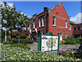
Old Garstang Council Offices
This large, red brick building is at the top of High Street. It was built in 1913 for the Board of Guardians and Garstang Rural District Council (later absorbed into Wyre Borough Council under Local Government Reorganisation in 1974). It is now used for a number of purposes.
Image: © David Dixon
Taken: 26 Jul 2011
0.14 miles
2
Garstang Arts Centre
The front part of the Arts Centre was originally the Boys' Grammar School, built in 1756 and closed in 1928.
It is a Grade II listed building (http://www.britishlistedbuildings.co.uk/en-185513-arts-centre-garstang British Listed Buildings)
Image: © David Dixon
Taken: 26 Jul 2011
0.14 miles
3
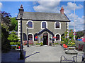
The Arts Centre
The front part of the Arts Centre was originally the Boys' Grammar School, built in 1756 and closed in 1928.
It is a Grade II listed building (http://www.britishlistedbuildings.co.uk/en-185513-arts-centre-garstang British Listed Buildings)
Image: © David Dixon
Taken: 26 Jul 2011
0.14 miles
4

Garstang Football Club
Taken on the Wyre Way at the ground of Garstang Football, Rugby and Cricket Clubs. Garstang, Lancashire.
Image: © Carroll Pierce
Taken: 17 Jan 2022
0.15 miles
5
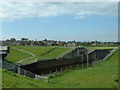
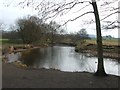
Garstang Water Basin
This engineering complex on the River Wyre serves two purposes. It is part of the engineering project whereby water is abstracted from the River Lune above its tidal reaches and pumped via the 5km long Quernmore Pipeline & the 6.6km long Wyresdale Tunnel, which discharge the water into the River Wyre at Abbeystead Outfall Station. The water then uses the river as a natural carrier to Garstang where the water is abstracted at the intake shown in the photograph and pumped to Franklaw Water Treatment Works at Catterall. After treatment the water is available for public water supply in the Fylde Area. This scheme supplements water taken from boreholes in the Fylde Area and Stocks Reservoir at Slaidburn. It also has a barrage which is raised when there is risk of flooding downstream at St Michaels [where the Wyre becomes tidal]. The bank of the flood basin can be seen beyond the rugby pitch - which becomes a lake when the barriers are raised.
Image: © David Medcalf
Taken: 1 May 2005
0.15 miles
6
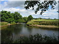
River Wyre from Garstang Car Park
View of the River Wyre on a summer's day. Greenhalgh Castle is in the distance.
Image: © Brian Houghton
Taken: Unknown
0.15 miles
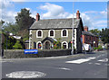
8
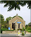
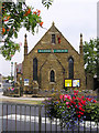
United Reformed Church, Garstang
Originally the Congregational Church.
Image: © Brian Houghton
Taken: 17 Aug 2006
0.15 miles