IMAGES TAKEN NEAR TO
Lancaster Road, PRESTON, PR3 1JF
Introduction
This page details the photographs taken nearby to Lancaster Road, PR3 1JF by members of the Geograph project.
The Geograph project started in 2005 with the aim of publishing, organising and preserving representative images for every square kilometre of Great Britain, Ireland and the Isle of Man.

There are currently over 7.5m images from over14,400 individuals and you can help contribute to the project by visiting https://www.geograph.org.uk
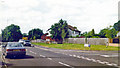
Image Map (Loading...)


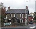
Getting Data...Please wait
Leaflet Map data © OpenStreetMap
Images are licensed for reuse under creativecommons.org/licenses/by-sa/2.0
Notes
- Clicking on the map will re-center to the selected point.
- The higher the marker number, the further away the image location is from the centre of the postcode.
Image Listing (40 Images Found)
Images are licensed for reuse under creativecommons.org/licenses/by-sa/2.0
Image
Details
Distance
1
Site of former Garstang Town station, 1996
View northward on Coston Road at Station Way. The station had been to the right, on the ex-LNWR Garstang & Catterall (to right) - (to left) Knott End branch, which closed to passengers 31/3/30, to goods 13/11/50.
Image: © Ben Brooksbank
Taken: 26 Jun 1996
0.15 miles
2
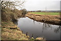
River Wyre at Garstang
Here the river forms the eastern boundary of the Millennium Park.
Image: © Bob Jenkins
Taken: 17 Feb 2009
0.16 miles
3
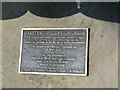
Garstang Millennium Green Sculpture plaque
Information plaque on the sculpture.Image]
Image: © Tony Mercer
Taken: 17 Jun 2010
0.17 miles
4
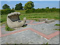
Garstang Millennium Green Sculpture
See Image] for description written on the plaque on the hand.
Image: © Tony Mercer
Taken: 17 Jun 2010
0.17 miles
5
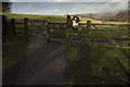
Millennium Way Footpath, Garstang
The Milleniniun Way follows the River Wyre upstream to Scorton
Image: © Tom Richardson
Taken: 17 Jan 2010
0.19 miles
6
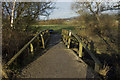
Footbridge on Millennium Way to Scorton
Image: © Tom Richardson
Taken: 17 Jan 2010
0.20 miles
7
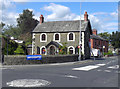
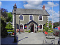
Garstang Arts Centre
The front part of the Arts Centre was originally the Boys' Grammar School, built in 1756 and closed in 1928.
It is a Grade II listed building (http://www.britishlistedbuildings.co.uk/en-185513-arts-centre-garstang British Listed Buildings)
Image: © David Dixon
Taken: 26 Jul 2011
0.20 miles
8
The Arts Centre
The front part of the Arts Centre was originally the Boys' Grammar School, built in 1756 and closed in 1928.
It is a Grade II listed building (http://www.britishlistedbuildings.co.uk/en-185513-arts-centre-garstang British Listed Buildings)
Image: © David Dixon
Taken: 26 Jul 2011
0.20 miles
9
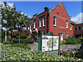
Old Garstang Council Offices
This large, red brick building is at the top of High Street. It was built in 1913 for the Board of Guardians and Garstang Rural District Council (later absorbed into Wyre Borough Council under Local Government Reorganisation in 1974). It is now used for a number of purposes.
Image: © David Dixon
Taken: 26 Jul 2011
0.21 miles