IMAGES TAKEN NEAR TO
Calder House Court, PRESTON, PR3 1GA
Introduction
This page details the photographs taken nearby to Calder House Court, PR3 1GA by members of the Geograph project.
The Geograph project started in 2005 with the aim of publishing, organising and preserving representative images for every square kilometre of Great Britain, Ireland and the Isle of Man.

There are currently over 7.5m images from over14,400 individuals and you can help contribute to the project by visiting https://www.geograph.org.uk
Image Map (Loading...)


Getting Data...Please wait
Leaflet Map data © OpenStreetMap
Images are licensed for reuse under creativecommons.org/licenses/by-sa/2.0
Notes
- Clicking on the map will re-center to the selected point.
- The higher the marker number, the further away the image location is from the centre of the postcode.
Image Listing (16 Images Found)
Images are licensed for reuse under creativecommons.org/licenses/by-sa/2.0
Image
Details
Distance
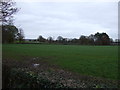
4
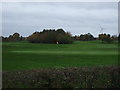
Golf Course
Garstang Country Hotel and Golf Centre.
Image: © JThomas
Taken: 16 Nov 2013
0.13 miles
8
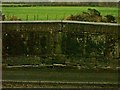
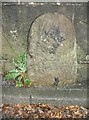
Old Boundary Marker by the B6430, Garstang Road, Calder Bridge
Parish Boundary Marker by the B6430, in parish of Barnacre with Bonds (Wyre District), Garstang Road, Calder Bridge, legend in bridge, East side of road. The bridge is dated 1812.
Inscription reads:-
BARNAKER WITH BONDS | CATTERALL
Calder Bridge is Grade II listed.
List Entry Number: 1072932 https://historicengland.org.uk/listing/the-list/list-entry/1072932
Surveyed
Milestone Society National ID: LA_PSGS08apb
Image: © Milestone Society
Taken: Unknown
0.20 miles
9
Old Boundary Marker by the B6430, on Calder Bridge, Garstang Road
Parish Boundary Marker by the B6430, in parish of Barnacre with Bonds (Wyre District), Garstang Road, Calder Bridge, on bridge over river, West side of road.
Surveyed
Milestone Society National ID: LA_PSGS08bpb.
Image: © Milestone Society
Taken: Unknown
0.20 miles
10
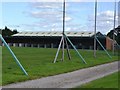
Driving range at Garstang Golf Centre
The wild scatter of balls makes you glad for the netting.
Image: © John M
Taken: 25 Jul 2015
0.20 miles