IMAGES TAKEN NEAR TO
High Street, PRESTON, PR3 1EB
Introduction
This page details the photographs taken nearby to High Street, PR3 1EB by members of the Geograph project.
The Geograph project started in 2005 with the aim of publishing, organising and preserving representative images for every square kilometre of Great Britain, Ireland and the Isle of Man.

There are currently over 7.5m images from over14,400 individuals and you can help contribute to the project by visiting https://www.geograph.org.uk
Image Map (Loading...)


Getting Data...Please wait
Leaflet Map data © OpenStreetMap
Images are licensed for reuse under creativecommons.org/licenses/by-sa/2.0
Notes
- Clicking on the map will re-center to the selected point.
- The higher the marker number, the further away the image location is from the centre of the postcode.
Image Listing (118 Images Found)
Images are licensed for reuse under creativecommons.org/licenses/by-sa/2.0
Image
Details
Distance
1
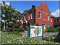
Old Garstang Council Offices
This large, red brick building is at the top of High Street. It was built in 1913 for the Board of Guardians and Garstang Rural District Council (later absorbed into Wyre Borough Council under Local Government Reorganisation in 1974). It is now used for a number of purposes.
Image: © David Dixon
Taken: 26 Jul 2011
0.02 miles
2
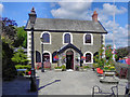
Garstang Arts Centre
The front part of the Arts Centre was originally the Boys' Grammar School, built in 1756 and closed in 1928.
It is a Grade II listed building (http://www.britishlistedbuildings.co.uk/en-185513-arts-centre-garstang British Listed Buildings)
Image: © David Dixon
Taken: 26 Jul 2011
0.03 miles
3
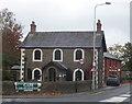
The Arts Centre
The front part of the Arts Centre was originally the Boys' Grammar School, built in 1756 and closed in 1928.
It is a Grade II listed building (http://www.britishlistedbuildings.co.uk/en-185513-arts-centre-garstang British Listed Buildings)
Image: © David Dixon
Taken: 26 Jul 2011
0.03 miles
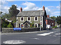
5
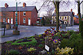
High Street, Garstang
Showing the junction with Croston Road; in the foreground the display is a small war memorial garden.
Image: © Stephen McKay
Taken: 21 Dec 2018
0.05 miles
7
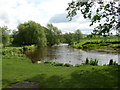
The River Wyre near to the car park, Garstang
Another version of a favourite view, this one taken in mid-May.
Image: © Humphrey Bolton
Taken: 14 May 2007
0.06 miles
8

Garstang Football Club
Taken on the Wyre Way at the ground of Garstang Football, Rugby and Cricket Clubs. Garstang, Lancashire.
Image: © Carroll Pierce
Taken: 17 Jan 2022
0.06 miles
10

River Wyre at High Street car park
This is the River Wyre as it meanders by the High Street car park in Garstang, Lancashire.
Image: © Carroll Pierce
Taken: 17 Jan 2022
0.07 miles