IMAGES TAKEN NEAR TO
Stuart Close, PRESTON, PR2 6AL
Introduction
This page details the photographs taken nearby to Stuart Close, PR2 6AL by members of the Geograph project.
The Geograph project started in 2005 with the aim of publishing, organising and preserving representative images for every square kilometre of Great Britain, Ireland and the Isle of Man.

There are currently over 7.5m images from over14,400 individuals and you can help contribute to the project by visiting https://www.geograph.org.uk
Image Map
Images are licensed for reuse under creativecommons.org/licenses/by-sa/2.0
Notes
- Clicking on the map will re-center to the selected point.
- The higher the marker number, the further away the image location is from the centre of the postcode.
Image Listing (18 Images Found)
Images are licensed for reuse under creativecommons.org/licenses/by-sa/2.0
Image
Details
Distance
2
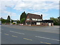
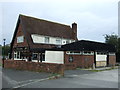
The Ribble Lodge pub
Situated to catch passing traffic on Ribbleton Avenue (it was early morning, the passing traffic was passing and not stopping on this occasion)
Image: © Richard Law
Taken: 22 May 2019
0.14 miles
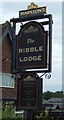
5
The Ribble Lodge public house
On Ribbleton Avenue.
Image: © JThomas
Taken: 24 Sep 2016
0.15 miles
6
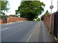
Cromwell Road crosses the former railway
Beneath here, and long disused, ran the Preston and Longridge Railway, which opened in 1840. It was originally envisaged as a route to carry stone from quarries at Longridge into the city for building, but developed passenger services quite early; steam locos were introduced in 1848. There were plans drawn up (more than once) to extend the line way out into North Yorkshire, and westwards to the coast at Fleetwood, but these never really came to fruition, and the line eventually closed to passengers in the early 1930s and to freight in the late 1960s.
Image: © Richard Law
Taken: 22 May 2019
0.16 miles
7
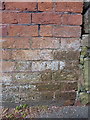
OS benchmark - Ribbleton 164 Ribbleton Avenue
A very weathered OS cutmark on the wall of an outbuilding on Ribbleton Avenue. It's not entirely clear if this is the one marked on maps around 1910 at 176.4 feet above Liverpool datum, or whether it's a more recent replacement levelled in 1961 at 52.429m above Ordnance Datum Newlyn. Personally I suspect it's the former, based on the type of bricks, and the amount of weathering as much as anything else.
Image: © Richard Law
Taken: 22 May 2019
0.17 miles
8
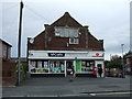
Post office and shop on Ribbleton Avenue
Showing position of Postbox No. PR2 109.
See Image] for postbox.
Image: © JThomas
Taken: 24 Sep 2016
0.19 miles
9
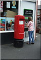
Elizabeth II postbox outside Post office on Ribbleton Avenue
Postbox No. PR2 109.
See Image] for context
Image: © JThomas
Taken: 24 Sep 2016
0.19 miles
10
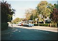
Bus on Ribbleton Avenue, Ribbleton
Stagecoach Lancashire 20475, one of the huge quantity of Volvo B10M/Alexander PS buses bought by Stagecoach in the 1990s, pauses at the traffic lights at the Cromwell Road junction while working route 2A from Longridge to Preston.
Image: © Richard Vince
Taken: 23 Sep 2006
0.19 miles