IMAGES TAKEN NEAR TO
Melrose Gardens, LEYLAND, PR26 9HR
Introduction
This page details the photographs taken nearby to Melrose Gardens, PR26 9HR by members of the Geograph project.
The Geograph project started in 2005 with the aim of publishing, organising and preserving representative images for every square kilometre of Great Britain, Ireland and the Isle of Man.

There are currently over 7.5m images from over14,400 individuals and you can help contribute to the project by visiting https://www.geograph.org.uk
Image Map
Images are licensed for reuse under creativecommons.org/licenses/by-sa/2.0
Notes
- Clicking on the map will re-center to the selected point.
- The higher the marker number, the further away the image location is from the centre of the postcode.
Image Listing (114 Images Found)
Images are licensed for reuse under creativecommons.org/licenses/by-sa/2.0
Image
Details
Distance
1
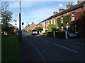
Highfield Road, Croston (A581)
Heading north towards Chorley.
Image: © JThomas
Taken: 11 Oct 2014
0.05 miles
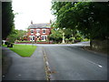
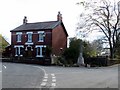
3
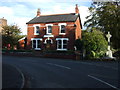
House on Highfield Road, Croston
War Memorial to the right.
Image: © JThomas
Taken: 11 Oct 2014
0.05 miles
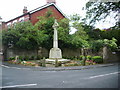
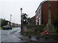
6
Croston war memorial and the junction of Grape Lane
Situated at the south eastern end of the village, opposite the Rectory gates.
Image: © Bill Boaden
Taken: 4 May 2013
0.06 miles
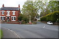
7
Road junction
The junction of Grape Lane, Town Road and Highfield Road
Image: © Alexander P Kapp
Taken: 26 Aug 2008
0.06 miles
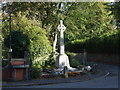
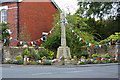
8
Croston War Memorial
On the corner of Grape Lane.
Image: © philandju
Taken: 16 Apr 2014
0.06 miles