IMAGES TAKEN NEAR TO
Roshaw, PRESTON, PR2 5RH
Introduction
This page details the photographs taken nearby to Roshaw, PR2 5RH by members of the Geograph project.
The Geograph project started in 2005 with the aim of publishing, organising and preserving representative images for every square kilometre of Great Britain, Ireland and the Isle of Man.

There are currently over 7.5m images from over14,400 individuals and you can help contribute to the project by visiting https://www.geograph.org.uk
Image Map
Images are licensed for reuse under creativecommons.org/licenses/by-sa/2.0
Notes
- Clicking on the map will re-center to the selected point.
- The higher the marker number, the further away the image location is from the centre of the postcode.
Image Listing (23 Images Found)
Images are licensed for reuse under creativecommons.org/licenses/by-sa/2.0
Image
Details
Distance
1
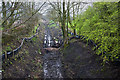
The disused railway doesn't make a very inviting path in this direction
Image: © Ian Greig
Taken: 28 Mar 2014
0.12 miles
2
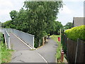
Footbridge Over and Access to Disused Railway
Image: © Sue Adair
Taken: 9 Jun 2007
0.12 miles
3
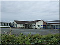
St Michael's Church of England Primary School, Grimsargh
Image: © JThomas
Taken: 24 Sep 2016
0.15 miles
4
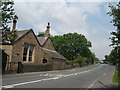
The Old School, Grimsargh
Looking north on Longridge Road, Grimsargh showing the old school, opened in 1809, to the left and the bridge over the old Preston to Longridge railway line.
Image: © Sue Adair
Taken: 9 Jun 2007
0.18 miles
6
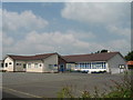
St Michael's C of E Primary School, Grimsargh
Image: © Sue Adair
Taken: 9 Jun 2007
0.18 miles
7
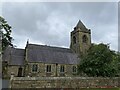
St Michael, Church of England, Grimsargh
The church is constructed in sandstone and has slate roofs. Its plan consists of a five-bay nave with a north aisle, a single-bay chancel, a north vestry, and a west tower. The architectural style is Decorated. The tower is in three stages, with a stair turret to the southeast and angle buttresses. In the top stage are three-light bell openings, and the tower is surmounted by a battlemented parapet and a pyramidal roof. Along the south side of the church are two-light windows and a gabled porch. The east window has three lights. In the wall of the north aisle are two-light square-headed windows. The vestry has a north doorway, and there are two windows in the east wall.
A chapel was built on the site of the present church in 1716, and a north aisle and a chancel were added in 1840. Between 1868 and 1871 the Lancaster architects Paley and Austin carried out work on the church. They rebuilt the nave, providing seating for 220 people, and added a tower. This cost £3,000 (£200,000 as of 2012), and was paid for by the Revd John Cross.
Image: © Rude Health
Taken: 4 Nov 2012
0.20 miles
8
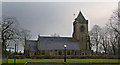
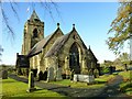
The Parish Church of Grimsagh, St Michael
Image: © Ian Greig
Taken: 28 Mar 2014
0.20 miles
9
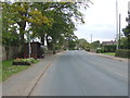
Bus stop and shelter on Preston Road, Grimsargh
Looking north.
Image: © JThomas
Taken: 24 Sep 2016
0.20 miles
10
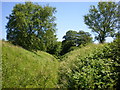
Dismantled railway
http://www.lancashire.gov.uk/corporate/web/view.asp?siteid=4438&pageid=20247&e=e
Image: © Alexander P Kapp
Taken: 24 Jun 2009
0.20 miles