IMAGES TAKEN NEAR TO
West Paddock, LEYLAND, PR25 9SE
Introduction
This page details the photographs taken nearby to West Paddock, PR25 9SE by members of the Geograph project.
The Geograph project started in 2005 with the aim of publishing, organising and preserving representative images for every square kilometre of Great Britain, Ireland and the Isle of Man.

There are currently over 7.5m images from over14,400 individuals and you can help contribute to the project by visiting https://www.geograph.org.uk
Image Map
Images are licensed for reuse under creativecommons.org/licenses/by-sa/2.0
Notes
- Clicking on the map will re-center to the selected point.
- The higher the marker number, the further away the image location is from the centre of the postcode.
Image Listing (42 Images Found)
Images are licensed for reuse under creativecommons.org/licenses/by-sa/2.0
Image
Details
Distance
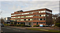
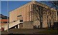
2
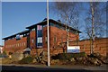
South Ribble Council offices
From West Paddock
Image: © Maureen Taylor
Taken: 4 Jan 2009
0.04 miles
3
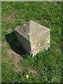
Old Boundary Marker by West Paddock, Leyland
Estate Boundary Marker in parish of Leyland (South Ribble District), West Paddock, in grass area, 20m from road, 25m West of junction with Roberts Close.
Surveyed
Milestone Society National ID: LA_LEY01em
Image: © Milestone Society
Taken: Unknown
0.07 miles
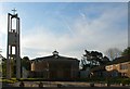
6
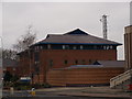
Leyland Police Station
From edge of Tesco car park
Image: © Maureen Taylor
Taken: 4 Jan 2009
0.11 miles
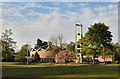
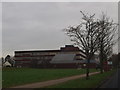
8
Leyland fire station
Leyland fire station, Broadfield Drive, Leyland, Lancashire.
Image: © Kevin Hale
Taken: 22 Oct 2006
0.12 miles
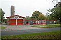
10
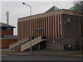
Leyland Magistrates' Court
From Tesco car park
Image: © Maureen Taylor
Taken: 4 Jan 2009
0.13 miles