IMAGES TAKEN NEAR TO
Queenscourt Avenue, PRESTON, PR1 9BT
Introduction
This page details the photographs taken nearby to Queenscourt Avenue, PR1 9BT by members of the Geograph project.
The Geograph project started in 2005 with the aim of publishing, organising and preserving representative images for every square kilometre of Great Britain, Ireland and the Isle of Man.

There are currently over 7.5m images from over14,400 individuals and you can help contribute to the project by visiting https://www.geograph.org.uk
Image Map (Loading...)


Getting Data...Please wait
Leaflet Map data © OpenStreetMap
Images are licensed for reuse under creativecommons.org/licenses/by-sa/2.0
Notes
- Clicking on the map will re-center to the selected point.
- The higher the marker number, the further away the image location is from the centre of the postcode.
Image Listing (8 Images Found)
Images are licensed for reuse under creativecommons.org/licenses/by-sa/2.0
Image
Details
Distance
1
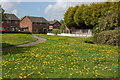
Dandelions on the park
Each springtime the little park between Sumpter Croft and the bridle path which stretches between Studholme Crescent and Winslow Close is awash with dandelions - no doubt South Ribble Borough Council will come along shortly and chop them all off !!!
Image: © Mari Buckley
Taken: 2 May 2009
0.12 miles
2
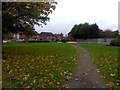
Autumn leaves on the park
I took a walk this afternoon across the little park by our bridle path...in the spring, this grass is covered with dandelions. Today it was covered with leaves!
Image: © Mari Buckley
Taken: 28 Oct 2010
0.12 miles
3
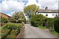
The bridle path between Studholme Crescent and Winslow Close
This little footpath/bridle path runs alongside the little park, on the left, and the old farmhouse of Studholme Farm. The white cottages on the right are on Giller Drive, and are old farm workers' cottages. The big tree in the middle is a protected tree, of historical importance, and is home to many a magpie !!
Image: © Mari Buckley
Taken: 2 May 2009
0.15 miles
4
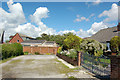
Our "non-existent" road !!
I have only just noticed that our little road, containing just 4 bungalows, appears to have been omitted from the Ordnance Survey map, but it IS here, I can assure you, and has been since 1960 !!!
Image: © Mari Buckley
Taken: 13 Aug 2007
0.17 miles
5
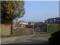
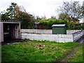
The back garden becomes a building site...
This lovely back garden continues to be cleared, ready for a couple of large houses to be plonked on it...see Image for a previous view, taken on 27th August. Little do the greedy builders know that this garden is prone to flooding.....
Image: © Mari Buckley
Taken: 6 Oct 2010
0.17 miles
6
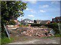
The ruination of a perfectly good back garden
This used to be a beautiful back garden with trees and shrubs belonging to one of the cottages on Gillar Drive, until some builders got their hands on it, seeing it not as a garden but as a building plot. The garden had no access, but they have been allowed to come down here and turn our peaceful little close into a building site. It's a disgrace.......
Image: © Mari Buckley
Taken: 27 Aug 2010
0.18 miles
7
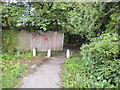
Pathway from Bee Lane to Sumpter Croft
This public pathway is a convenient shortcut if you need to get from Bee Lane to Sumpter Croft and back again. As it's not lit, it's a bit spooky at night though!
Image: © Mari Buckley
Taken: 5 Jul 2009
0.21 miles