IMAGES TAKEN NEAR TO
Holly Close, PR1 9BG
Introduction
This page details the photographs taken nearby to Holly Close, PR1 9BG by members of the Geograph project.
The Geograph project started in 2005 with the aim of publishing, organising and preserving representative images for every square kilometre of Great Britain, Ireland and the Isle of Man.

There are currently over 7.5m images from over14,400 individuals and you can help contribute to the project by visiting https://www.geograph.org.uk
Image Map (Loading...)


Getting Data...Please wait
Leaflet Map data © OpenStreetMap
Images are licensed for reuse under creativecommons.org/licenses/by-sa/2.0
Notes
- Clicking on the map will re-center to the selected point.
- The higher the marker number, the further away the image location is from the centre of the postcode.
Image Listing (20 Images Found)
Images are licensed for reuse under creativecommons.org/licenses/by-sa/2.0
Image
Details
Distance
1
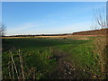
Former gasworks site off Wateringpool Lane
This land has long been earmarked for development. In August 2015 planning permission was given for the building of 280 homes on the site: https://web.archive.org/web/20151229180207/http://www.leylandguardian.co.uk/news/local/former-gasworks-site-gets-the-go-ahead-for-280-new-homes-1-7411180
Image: © Adam C Snape
Taken: 27 Dec 2015
0.05 miles
2
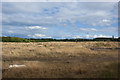
Currently open land at the end of The Cawsey
Formerly industrial or MOD land
Image: © Ian Greig
Taken: 7 Sep 2013
0.06 miles
3
Currently open land at the end of The Cawsey
It looks to have previously been used for industrial buildings and is probably ear-marked for development.
Image: © Ian Greig
Taken: 7 Sep 2013
0.11 miles
4
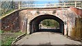
Leigh Brow Bridge
See Imagefor a view of the other side and for more information.
Image: © Paul Collins
Taken: 14 Apr 2018
0.13 miles
5
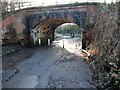
Leigh Brow Bridge
A former railway bridge which now only serves to carry a foot and cycle path over the road.
The road is a narrow lane which once formed part of a through route from Lostock Hall to Walton-le-Dale. It is now restricted to non-motorised traffic. Its name changes from Leigh Brow to Wateringpool Lane at the bridge. The view back up Leigh Brow can be seen here: Image
A short distance along Wateringpool Lane is a former gasworks. During the era when coal gas was used, coal wagons would regularly end up wedged under this low bridge on their way to the gasworks.
Image: © Adam C Snape
Taken: 27 Dec 2015
0.13 miles
6
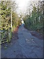
Leigh Brow
The name of the road changes from Wateringpool Lane to Leigh Brow at Leigh Brow Bridge.
This narrow lane which once formed part of a through route from Lostock Hall to Walton-le-Dale is now restricted to non-motorised traffic.
At the top of the brow is the Walton Park housing estate. The gate to the left provides access to the old railway foot/cycle path. Leigh Brow Bridge is just behind the photographer (see Image).
Image: © Adam C Snape
Taken: 27 Dec 2015
0.15 miles
7
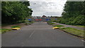
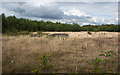
Cross borough link road under construction
The new bridge to link Carrwood Road and The Cawsey is built. Construction is now underway to link it to Carrwood Road.
Image: © Antony Walmsley
Taken: 26 May 2019
0.16 miles
8
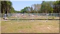
Site of the new bridge
Looking east towards Carrwood Road from the route of the new link road. It can be seen that the trees surrounding the old railway have been cleared pending the construction of the new bridge.
See also: Image
Image: © Adam C Snape
Taken: 12 May 2016
0.17 miles
9
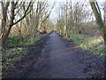
View along the cycle path towards the site of the proposed link road bridge
Housing development on the old gasworks site to the west is dependent upon the construction of a new link road connecting Walton-le Dale and Penwortham through the pre-existing estate roads Carrwood Road and The Cawsey. It is proposed that the link road will pass over this nature reserve and cycle path by means of a bridge at this point.
View from Carrwood Road: Image
More details about the development and link road: https://web.archive.org/web/20151229180207/http://www.leylandguardian.co.uk/news/local/former-gasworks-site-gets-the-go-ahead-for-280-new-homes-1-7411180
Image: © Adam C Snape
Taken: 27 Dec 2015
0.18 miles
10
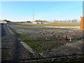
The gasometers have been dismantled
The last significant parts of the gasworks off Wateringpool Lane have been removed. Two large gas holding tanks stood in this location for many years. In August 2015 planning permission was given for the building of 280 homes on the former gasworks site: https://web.archive.org/web/20151229180207/http://www.leylandguardian.co.uk/news/local/former-gasworks-site-gets-the-go-ahead-for-280-new-homes-1-7411180
Image: © Adam C Snape
Taken: 27 Dec 2015
0.18 miles