IMAGES TAKEN NEAR TO
Langton Street, PRESTON, PR1 8PY
Introduction
This page details the photographs taken nearby to Langton Street, PR1 8PY by members of the Geograph project.
The Geograph project started in 2005 with the aim of publishing, organising and preserving representative images for every square kilometre of Great Britain, Ireland and the Isle of Man.

There are currently over 7.5m images from over14,400 individuals and you can help contribute to the project by visiting https://www.geograph.org.uk
Image Map
Images are licensed for reuse under creativecommons.org/licenses/by-sa/2.0
Notes
- Clicking on the map will re-center to the selected point.
- The higher the marker number, the further away the image location is from the centre of the postcode.
Image Listing (137 Images Found)
Images are licensed for reuse under creativecommons.org/licenses/by-sa/2.0
Image
Details
Distance
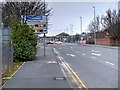
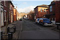
1
Access to the bins
In this area of terraced houses the narrow back lanes between each pair of parallel terraces are gated, presumably for security.
Image: © M J Richardson
Taken: 23 Oct 2021
0.03 miles
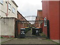
2
Hartington Road
With Northcote Road joining from the left. An area of terraced housing dating from the mid-1800s. The nearest house, with post box, was a corner shop [Google Street View imagery, 2014]. The Northcote Road wall has the remains of a 'Gold Flake cigarettes' advertisement - see Image
Image: © M J Richardson
Taken: 23 Oct 2021
0.04 miles
3
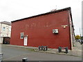
GOLD FLAKE CIGARETTES
Legacy advertising, on the Northcote Road end of a Hartington Road terrace house that was once a corner shop Image
Image: © M J Richardson
Taken: 23 Oct 2021
0.04 miles
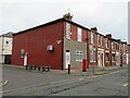
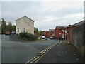
4
Christ Church Street, Preston
A road parallel to Fishergate Hill. With a name like this, I expected to see a church but there wasn't one.
Image: © Bill Boaden
Taken: 18 Feb 2012
0.05 miles
5
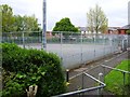
Recreation Ground
Former bowling green
Image: © Alex McGregor
Taken: 1 May 2014
0.07 miles
6
Houses in Preston
Euston Street to the left, Fitzroy Street to the right, with the ends of terraces to the right.
Image: © M J Richardson
Taken: 22 Oct 2021
0.08 miles
7
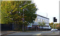
Hartington Road
Off Fishergate Hill. The Preston Depot of Electricity North West can be seen.
Image: © Thomas Nugent
Taken: 19 Oct 2018
0.10 miles
8
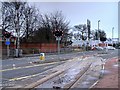
Strand Road Crossing
Part of the large railway network that used to serve the vast docks and quays at Preston.
Image: © David Dixon
Taken: 14 Jan 2015
0.11 miles
9
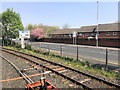
Ribble Steam Railway, Strand Road
The railway lines around Preston Dock largely fell into disuse after the closure of the docks. A preservation group that had been operating in Southport relocated to Preston in 1999 and began operating as the Ribble Steam Railway in 2005. The Railway runs passenger trains from a base at Preston Riverside Station as far as Strand Road which is the eastern terminus of the line although there is no facility for passengers to alight or for locomotives to run round their train here.
Image: © David Dixon
Taken: 22 Apr 2019
0.11 miles