IMAGES TAKEN NEAR TO
Ribble Bank Street, PRESTON, PR1 8NF
Introduction
This page details the photographs taken nearby to Ribble Bank Street, PR1 8NF by members of the Geograph project.
The Geograph project started in 2005 with the aim of publishing, organising and preserving representative images for every square kilometre of Great Britain, Ireland and the Isle of Man.

There are currently over 7.5m images from over14,400 individuals and you can help contribute to the project by visiting https://www.geograph.org.uk
Image Map
Images are licensed for reuse under creativecommons.org/licenses/by-sa/2.0
Notes
- Clicking on the map will re-center to the selected point.
- The higher the marker number, the further away the image location is from the centre of the postcode.
Image Listing (92 Images Found)
Images are licensed for reuse under creativecommons.org/licenses/by-sa/2.0
Image
Details
Distance
1
Houses in Preston
Euston Street to the left, Fitzroy Street to the right, with the ends of terraces to the right.
Image: © M J Richardson
Taken: 22 Oct 2021
0.06 miles
3
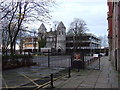
Register Office, Bow Lane, Preston
A modern extension, built in 1965 by the County Architect's Department. Quite good, with glass set back within a concrete frame.
Image: © Stephen Richards
Taken: 11 Jun 2013
0.13 miles
4
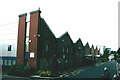
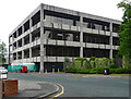
Preston - Marsh Building University of Central Lancashire
A former LNWR Goods warehouse
Image: © Alan Longbottom
Taken: 11 Aug 2007
0.14 miles
5
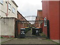
Access to the bins
In this area of terraced houses the narrow back lanes between each pair of parallel terraces are gated, presumably for security.
Image: © M J Richardson
Taken: 23 Oct 2021
0.14 miles
7
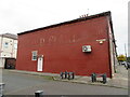
GOLD FLAKE CIGARETTES
Legacy advertising, on the Northcote Road end of a Hartington Road terrace house that was once a corner shop Image
Image: © M J Richardson
Taken: 23 Oct 2021
0.15 miles
8
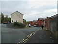
Hartington Road
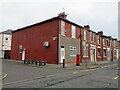
With Northcote Road joining from the left. An area of terraced housing dating from the mid-1800s. The nearest house, with post box, was a corner shop [Google Street View imagery, 2014]. The Northcote Road wall has the remains of a 'Gold Flake cigarettes' advertisement - see Image
Image: © M J Richardson
Taken: 23 Oct 2021
0.15 miles
9
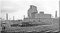
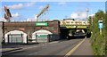
Preston Locomotive Depot, 1962
A scene westward from a passing train, of a Depot by now used only for storage of withdrawn locomotives since its closure on 12/9/61 following destruction by fire on 28/6/60. The locomotives seem to be mainly ex-LNWR 0-8-0s, the nearest being Nos. 49008 and 49447.
Image: © Ben Brooksbank
Taken: 8 Sep 1962
0.15 miles