IMAGES TAKEN NEAR TO
Swan Street, PRESTON, PR1 5NA
Introduction
This page details the photographs taken nearby to Swan Street, PR1 5NA by members of the Geograph project.
The Geograph project started in 2005 with the aim of publishing, organising and preserving representative images for every square kilometre of Great Britain, Ireland and the Isle of Man.

There are currently over 7.5m images from over14,400 individuals and you can help contribute to the project by visiting https://www.geograph.org.uk
Image Map
Images are licensed for reuse under creativecommons.org/licenses/by-sa/2.0
Notes
- Clicking on the map will re-center to the selected point.
- The higher the marker number, the further away the image location is from the centre of the postcode.
Image Listing (62 Images Found)
Images are licensed for reuse under creativecommons.org/licenses/by-sa/2.0
Image
Details
Distance
1
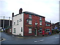
Fox & Grapes, Ribbleton Lane, Preston
Image: © Alexander P Kapp
Taken: 28 Jan 2008
0.08 miles
2
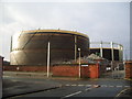
Gas holders off Geoffrey Street, Preston
These gas holders are still employed to store natural gas instead of the old type, "town gas"
Image: © Alexander P Kapp
Taken: 28 Jan 2008
0.08 miles
3
"Superpet Warehouse", Crook Street, Preston
They could soon run out of space for putting up a new sign
Image: © Alexander P Kapp
Taken: 16 Jan 2008
0.10 miles
4
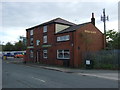
Fox & Grapes public house
On Ribbleton Lane, Preston
Showing position of Postbox No. PR1 111.
See Image] for postbox.
Image: © JThomas
Taken: 1 Oct 2016
0.10 miles
5
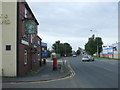
Ribbleton Lane, Preston
Showing position of Postbox No. PR1 111 outside the Fox & Grapes public house.
See Image] for postbox.
Image: © JThomas
Taken: 1 Oct 2016
0.10 miles
6
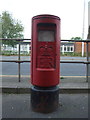
Elizabeth II postbox on Ribbleton Lane, Preston
Image: © JThomas
Taken: 1 Oct 2016
0.10 miles
7
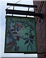
Sign for the Fox & Grapes public house, Preston
Image: © JThomas
Taken: 1 Oct 2016
0.10 miles
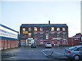
8
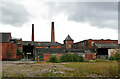
Alliance Works, Preston
This has been demolished and there is a new housing development on the site. I have placed the subject marker where my previous position was and the photographer marker on Geoffrey Street as that lines up with the Centenary Mill chimney. This is what happens when you wait ten years to post - the aerial and streetview images have changed.
Image: © Chris Allen
Taken: 1 Aug 2010
0.11 miles
9
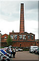
Alliance Works, Preston
This works with its square brick chimney has been replaced by a housing development. I believe this view was from the car parking area behind Centenary Mill. I would appreciate any assistance with the location. Alliance Works was a cotton weaving mill with large sheds to the rear.
Image: © Chris Allen
Taken: 1 Aug 2010
0.12 miles