IMAGES TAKEN NEAR TO
Maudland Bank, PRESTON, PR1 2YJ
Introduction
This page details the photographs taken nearby to Maudland Bank, PR1 2YJ by members of the Geograph project.
The Geograph project started in 2005 with the aim of publishing, organising and preserving representative images for every square kilometre of Great Britain, Ireland and the Isle of Man.

There are currently over 7.5m images from over14,400 individuals and you can help contribute to the project by visiting https://www.geograph.org.uk
Image Map
Images are licensed for reuse under creativecommons.org/licenses/by-sa/2.0
Notes
- Clicking on the map will re-center to the selected point.
- The higher the marker number, the further away the image location is from the centre of the postcode.
Image Listing (128 Images Found)
Images are licensed for reuse under creativecommons.org/licenses/by-sa/2.0
Image
Details
Distance
3
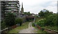
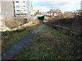
View from Maudland Bridge
The site of the disused Lancaster Canal goes horizontally across the middle of the shot. The tracks of a disused railway can also be seen. From 1856 to 1885 this was the site of Maudlands Bridge railway station, the terminus of a railway line to Longridge. The line closed to passengers in 1930 but continued to be used for goods until the 1990s.
Image: © Betty Longbottom
Taken: 12 Aug 2007
0.04 miles
4
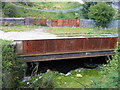
Lancaster Canal bridge, Maudland, Preston
The Lancaster Canal, which once terminated in the centre of Preston, has been cut back to Ashton, a mile or so to the north, and most of the abandoned section filled in or built over. However, there is still a small amount of scummy water under the bridge that carries the disused Deepdale branch over the line of the canal just north of Maudland Road. The bridge bears half a plate implying that it was built by Dallam Forge, Warrington, in 1883, when it was widened to enable trains from the branch to run into the main-line Preston station.
Image: © A-M-Jervis
Taken: 9 Aug 2007
0.04 miles
6
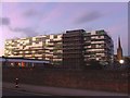
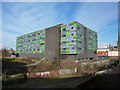
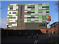
University building under construction
The media factory of the University of Central Lancashire under construction in 2007
Image: © Andrew Gritt
Taken: 23 Aug 2007
0.06 miles
7
Dismantled railway
Looking east off Maudland Bank, this railway did go as far as Longridge
Image: © Alexander P Kapp
Taken: 25 Nov 2010
0.07 miles
8
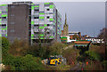
Proposed tramway site
Preston Trampower has approval to build a 1250m demonstration tramline along the old Preston and Longridge Railway trackbed, eastwards from here through Miley Tunnel to Deepdale Street.
Clearance work appears to have started, but little else. Compare with Image (2005) & Image (2015).
Image: © Ian Taylor
Taken: 6 Mar 2019
0.07 miles
9
The Media Factory, UCLan, Preston
The Media Factory is part of the University of Central Lancashire. It was completed in 2007 and officially opened on 24th January 2008.
Once the new building was completed the University sold the historic former Harris Institute building (named the 'Avenham Building' by UCLAN) which it had been using in previous years. Image
The picture is taken from the wonderfully-named Cold Bath Street. Between the photographer and the building is a bridge over a former railway. The former Maudland Bridge station was located at this point on the line Image
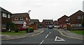
The road signs in the foreground are comically confusing!
Image: © Adam C Snape
Taken: 20 Dec 2015
0.07 miles
10
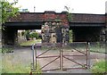
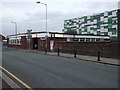
Maudland Bank
This bridge carries the road over a former railway line, now disused.
Image: © Betty Longbottom
Taken: 12 Aug 2007
0.07 miles