IMAGES TAKEN NEAR TO
Fishergate, PRESTON, PR1 2DA
Introduction
This page details the photographs taken nearby to Fishergate, PR1 2DA by members of the Geograph project.
The Geograph project started in 2005 with the aim of publishing, organising and preserving representative images for every square kilometre of Great Britain, Ireland and the Isle of Man.

There are currently over 7.5m images from over14,400 individuals and you can help contribute to the project by visiting https://www.geograph.org.uk
Image Map
Images are licensed for reuse under creativecommons.org/licenses/by-sa/2.0
Notes
- Clicking on the map will re-center to the selected point.
- The higher the marker number, the further away the image location is from the centre of the postcode.
Image Listing (446 Images Found)
Images are licensed for reuse under creativecommons.org/licenses/by-sa/2.0
Image
Details
Distance
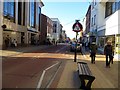
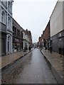
3
Junction of Fishergate and Guildhall Street
Image: © Basher Eyre
Taken: 7 Apr 2018
0.01 miles
4
No. 124 Fishergate, Preston
A 20C version of Classical style. I like the decoration at the foot of the second-floor windows. The building to the left of H Samuel's is odd in that the façade is not straight.
Image: © Humphrey Bolton
Taken: 22 Dec 2009
0.02 miles
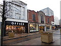
5
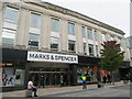
Marks & Spencer, Fishergate, Preston
No details of this building to be found, but it possibly dates back to its opening by M & S, as its logo is on the separators of each of the windows Image They moved to this site in 1929, after having a presence at two other sites on Fishergate since 1891.
Image: © M J Richardson
Taken: 23 Oct 2021
0.02 miles
6
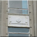
Marks & Spencer, Fishergate, Preston - detail
Detail of the M & S logo, which features on all the windows, and is assumed to date from when M & S moved to this site in 1929.
Image: © M J Richardson
Taken: 23 Oct 2021
0.02 miles
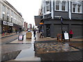
7
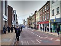
Fishergate, Looking West
Fishergate is the main shopping street in Preston with the usual stores M&S, BHS, WH Smiths etc.
Since 2014, the area has been designated as 'Shared space'; an urban design approach which reduces the markings separating vehicles and pedestrians which involves removing kerbs and traffic signs to produce a more open space with widened pavements incorporating trees (http://www.preston.gov.uk/yourservices/transport-and-parking/roads-and-pavements/fishergate-central-gateway-project/ Fishergate Central Gateway project, Preston City Council). Neither cars nor pedestrians have right of way and it has been claimed, by “traffic experts”, that this makes the road safer as drivers have to stay on their guard (http://www.blogpreston.co.uk/2014/10/seven-things-you-said-on-fishergate-new-layout-completion/ Blog Preston).
Image: © David Dixon
Taken: 14 Jan 2015
0.02 miles
8
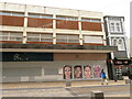
Bhs Preston - closed!
One of many Bhs stores that are no longer open, this has been closed and empty for 5 years.
Image: © M J Richardson
Taken: 23 Oct 2021
0.02 miles
9
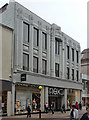
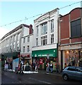
30-31 Fishergate, Preston
Particularly decorative Deco front of white faience. By William Priddle, 1922.
Built for Woolworths, at the time a branch of Next.
Image: © Stephen Richards
Taken: 11 Jun 2013
0.02 miles
10
Looking from Fishergate into Guildhall Street
Image: © Basher Eyre
Taken: 7 Apr 2018
0.03 miles