IMAGES TAKEN NEAR TO
Shaftesbury Avenue, PRESTON, PR1 0AY
Introduction
This page details the photographs taken nearby to Shaftesbury Avenue, PR1 0AY by members of the Geograph project.
The Geograph project started in 2005 with the aim of publishing, organising and preserving representative images for every square kilometre of Great Britain, Ireland and the Isle of Man.

There are currently over 7.5m images from over14,400 individuals and you can help contribute to the project by visiting https://www.geograph.org.uk
Image Map
Images are licensed for reuse under creativecommons.org/licenses/by-sa/2.0
Notes
- Clicking on the map will re-center to the selected point.
- The higher the marker number, the further away the image location is from the centre of the postcode.
Image Listing (30 Images Found)
Images are licensed for reuse under creativecommons.org/licenses/by-sa/2.0
Image
Details
Distance
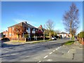
1
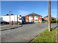
Higher Penwortham
The junction of Shaftesbury Avenue and Blundell Lane.
Image: © David Dixon
Taken: 4 Feb 2015
0.07 miles
2
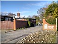
Entrance to Penwortham Golf Club
Golf club entrance at the end of Blundell Lane.
Image: © David Dixon
Taken: 4 Feb 2015
0.07 miles
7
Penwortham Golf Course
The clubhouse is in the background. This is taken from a path which skirts the golf course.
Image: © Bill Boaden
Taken: 18 Feb 2012
0.16 miles
8
Reclaimed green space
This has been developed as a leisure area though it still carries a faint air of dereliction. It is used by numerous joggers and dog-walkers.
Image: © Bill Boaden
Taken: 18 Feb 2012
0.18 miles
9
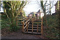
Steps to Castle Walk
The 1:25,000 OS map refers to a motte somewhere around here though does not specify the location clearly. The naming of the new residential road as Castle Walk is another clue and the house opposite continues this theme. However the nearest thing I found to a motte was in the churchyard.
Image: © Bill Boaden
Taken: 18 Feb 2012
0.22 miles
10
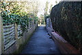
Path from Hollinhurst Avenue to Church Avenue
The cross ahead is a boundary marker between two gifts of land to the parish church in 1920.
Image: © Bill Boaden
Taken: 18 Feb 2012
0.22 miles