IMAGES TAKEN NEAR TO
Comley Hill, HAVANT, PO9 5ND
Introduction
This page details the photographs taken nearby to Comley Hill, PO9 5ND by members of the Geograph project.
The Geograph project started in 2005 with the aim of publishing, organising and preserving representative images for every square kilometre of Great Britain, Ireland and the Isle of Man.

There are currently over 7.5m images from over14,400 individuals and you can help contribute to the project by visiting https://www.geograph.org.uk
Image Map
Images are licensed for reuse under creativecommons.org/licenses/by-sa/2.0
Notes
- Clicking on the map will re-center to the selected point.
- The higher the marker number, the further away the image location is from the centre of the postcode.
Image Listing (14 Images Found)
Images are licensed for reuse under creativecommons.org/licenses/by-sa/2.0
Image
Details
Distance
2
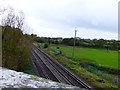
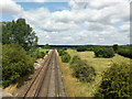
Looking across the railway from Comley Hill
This stretch of line is between Rowlands Castle and Havant.
Image: © Shazz
Taken: 3 Nov 2013
0.11 miles
5
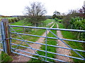
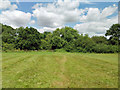
Bridleway off Comley Road
This goes to Woodberry Lane at Rowlands Castle.
Image: © Shazz
Taken: 3 Nov 2013
0.17 miles
6
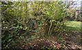
WWII Hampshire: environs of Havant & Emsworth - Comley Hill area pillbox no. 1 (7)
-
Pillbox (unclassified): DoB ID: S0012777
Somewhat ambiguously this is also classified as a pillbox/section post, presumably because it does bear some resemblance to a small section post or blockhouse. It is not L-shaped as described on the national database, but rectangular, with three south facing embrasures, and an entrance in the centre on the north side with loopholes at each end facing east and west. It is located within private grounds that once overlooked open ground bounded by the railway, Prospect Lane, and the Emsworth - Horndean road. It is heavily overgrown.
Image
Image: © Mike Searle
Taken: 7 Apr 2017
0.18 miles
7
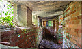
WWII Hampshire: environs of Havant & Emsworth - Comley Hill area pillbox no. 1 (8)
-
Pillbox (unclassified): DoB ID: S0012777
Interior end-to-end view through the southeast facing loophole showing the rectangular shape of the pillbox. The entrance on the north side is in the centre on the right.
Image
Image: © Mike Searle
Taken: 7 Apr 2017
0.18 miles
8
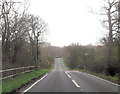
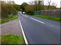
B2148 south of Rowlands Castle
The hump ahead is the railway bridge
Image: © John Firth
Taken: 15 Apr 2013
0.18 miles
9
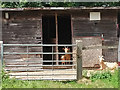
I kid you not
Hampshire shanty dwellers.
Image: © Robin Webster
Taken: 28 Jul 2019
0.18 miles
10
Railway north of B2148 bridge
The Portsmouth Direct Line, here between Havant and Rowlands Castle.
Image: © Robin Webster
Taken: 28 Jul 2019
0.20 miles