IMAGES TAKEN NEAR TO
London Road, WATERLOOVILLE, PO8 8DE
Introduction
This page details the photographs taken nearby to London Road, PO8 8DE by members of the Geograph project.
The Geograph project started in 2005 with the aim of publishing, organising and preserving representative images for every square kilometre of Great Britain, Ireland and the Isle of Man.

There are currently over 7.5m images from over14,400 individuals and you can help contribute to the project by visiting https://www.geograph.org.uk
Image Map
Images are licensed for reuse under creativecommons.org/licenses/by-sa/2.0
Notes
- Clicking on the map will re-center to the selected point.
- The higher the marker number, the further away the image location is from the centre of the postcode.
Image Listing (37 Images Found)
Images are licensed for reuse under creativecommons.org/licenses/by-sa/2.0
Image
Details
Distance
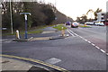

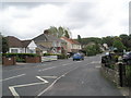
4
Junction of Hart Plain Avenue and Firs Avenue
Image: © Basher Eyre
Taken: 16 May 2009
0.11 miles
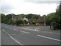
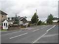
5
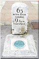
Old Milestone by the A3, London Road, Horndean Parish
Metal plate attached to stone post by the A3, in parish of HORNDEAN (EAST HAMPSHIRE District), London Road, Cowplain Village, opposite No. 4, in paved area with plaque set in front, on West side of road. Portsmouth limestone block and plate, erected by the Portsmouth & Sheet Bridge turnpike trust in the 19th century.
Inscription reads:-
65
miles from
London
9 from
Petersfield.
Milestone Society National ID: HA_LP61.
Image: © K Lawrence
Taken: 17 Aug 2003
0.12 miles
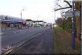
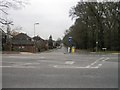
10
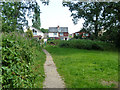
Queen's Inclosure - a way out
Part of the Forestry Commission's Bere Forest, which is much fragmented.
Image: © Robin Webster
Taken: 23 Jul 2014
0.13 miles