IMAGES TAKEN NEAR TO
Rookwood View, WATERLOOVILLE, PO7 6HT
Introduction
This page details the photographs taken nearby to Rookwood View, PO7 6HT by members of the Geograph project.
The Geograph project started in 2005 with the aim of publishing, organising and preserving representative images for every square kilometre of Great Britain, Ireland and the Isle of Man.

There are currently over 7.5m images from over14,400 individuals and you can help contribute to the project by visiting https://www.geograph.org.uk
Image Map
Images are licensed for reuse under creativecommons.org/licenses/by-sa/2.0
Notes
- Clicking on the map will re-center to the selected point.
- The higher the marker number, the further away the image location is from the centre of the postcode.
Image Listing (113 Images Found)
Images are licensed for reuse under creativecommons.org/licenses/by-sa/2.0
Image
Details
Distance
1
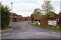
Rookwood View
A residential cul de sac off Park Road.
Image: © Peter Facey
Taken: 16 May 2012
0.01 miles
2
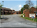
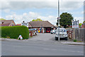
Rookwood View
Retirement and sheltered housing managed by Hanover.
Image: © Robin Webster
Taken: 23 Jul 2014
0.01 miles
3

Denmead Burial Ground, Cemetery Lane
Operated by Denmead Parish Council
Image: © Peter Facey
Taken: 27 Mar 2008
0.01 miles
4
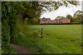
Footpath north of Rookwood View
The footpath turns 90 degrees left here. Houses in Rookwood View are beyond.
Image: © Peter Facey
Taken: 16 May 2012
0.03 miles
5
Footpath from Park Road to Pithill
Here leaving Park Road.
Image: © Peter Facey
Taken: 16 May 2012
0.04 miles
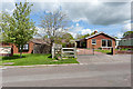
6
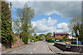
Park Road
An L-shaped residential road, this end joining the B2150 Hambledon Road.
Image: © Peter Facey
Taken: 16 May 2012
0.05 miles
7
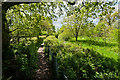
Footpath on west side of cemetery
(elevated camera position)
Image: © Peter Facey
Taken: 16 May 2012
0.06 miles
8
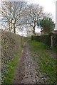
Rather muddy footpath from Cemetery Lane to Park Road, Denmead
Image: © Peter Facey
Taken: 27 Mar 2008
0.06 miles
10

Milestone, Denmead
Carved stone post with missing attachment by the B2150, in parish of Denmead (Winchester District), Lindsey House, Hambledon Road, Denmead, in wall of garden, near junction with Park Road, on North side of road. Soberton stone erected by an unknown authority in the 19th century.
Inscription reads: // Ports.th / 10 //
Not listed by Historic England. NGR: SU 6560 1205
Milestone Society National ID: HA_PODR10
Image: © John Thornton
Taken: 9 Jul 2020
0.08 miles