IMAGES TAKEN NEAR TO
Woods Square, WATERLOOVILLE, PO7 3AL
Introduction
This page details the photographs taken nearby to Woods Square, PO7 3AL by members of the Geograph project.
The Geograph project started in 2005 with the aim of publishing, organising and preserving representative images for every square kilometre of Great Britain, Ireland and the Isle of Man.

There are currently over 7.5m images from over14,400 individuals and you can help contribute to the project by visiting https://www.geograph.org.uk
Image Map
Images are licensed for reuse under creativecommons.org/licenses/by-sa/2.0
Notes
- Clicking on the map will re-center to the selected point.
- The higher the marker number, the further away the image location is from the centre of the postcode.
Image Listing (53 Images Found)
Images are licensed for reuse under creativecommons.org/licenses/by-sa/2.0
Image
Details
Distance
1
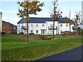
Housing, Berewood, Waterlooville
A new estate expanding Waterlooville to the west.
Image: © Robin Webster
Taken: 17 Nov 2019
0.02 miles
2
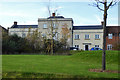
Houses, Berewood, Waterlooville
Looking like a renovation of something old, but in fact totally new build, as is the rest of the estate.
Image: © Robin Webster
Taken: 17 Nov 2019
0.02 miles
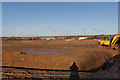
3
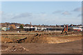
Earth moving on West of Waterlooville housing development site
Seen from modified footpath.
Image: © Peter Facey
Taken: 17 Dec 2011
0.02 miles
4
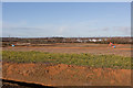
West of Watrelooville housing development site
Seen from revised footpath.
Image: © Peter Facey
Taken: 17 Dec 2011
0.08 miles
5
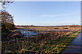
West of Waterlooville housing development site
Image: © Peter Facey
Taken: 17 Dec 2011
0.09 miles
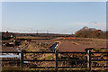
6
West of Waterlooville housing development site
Seen from corner of temporarily-diverted footpath over Plant Farm. The drainage ditch forms the southern boundary of the present phase of housing development, there being farmed land immediately behind the camera.
Image: © Peter Facey
Taken: 17 Dec 2011
0.10 miles
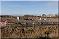
7
Embryo access roads and drains on West of Waterlooville housing development site
Seen from B2150 pavement.
Image: © Peter Facey
Taken: 17 Dec 2011
0.10 miles
8
Contractors Depot on West of Waterlooville housing development site
Seen from B2150 pavement.
Image: © Peter Facey
Taken: 17 Dec 2011
0.10 miles
9
Earth moving on West of Waterlooville housing development site
Showing 130LCN digger. At this point the new footpath turns 90 degrees right.
Image: © Peter Facey
Taken: 17 Dec 2011
0.11 miles
10
Earth moving on West of Waterlooville housing development site
Image: © Peter Facey
Taken: 17 Dec 2011
0.11 miles