IMAGES TAKEN NEAR TO
Lordington Close, PORTSMOUTH, PO6 2HJ
Introduction
This page details the photographs taken nearby to Lordington Close, PO6 2HJ by members of the Geograph project.
The Geograph project started in 2005 with the aim of publishing, organising and preserving representative images for every square kilometre of Great Britain, Ireland and the Isle of Man.

There are currently over 7.5m images from over14,400 individuals and you can help contribute to the project by visiting https://www.geograph.org.uk
Image Map
Images are licensed for reuse under creativecommons.org/licenses/by-sa/2.0
Notes
- Clicking on the map will re-center to the selected point.
- The higher the marker number, the further away the image location is from the centre of the postcode.
Image Listing (213 Images Found)
Images are licensed for reuse under creativecommons.org/licenses/by-sa/2.0
Image
Details
Distance
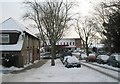
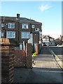
2
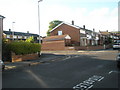
Junction of Racton Avenue and Lower Drayton Lane
Image: © Basher Eyre
Taken: 28 Apr 2008
0.05 miles
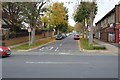
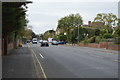
3
Looking down Penrhyn Avenue towards Havant Road
Image: © Basher Eyre
Taken: 9 Jan 2010
0.06 miles
6
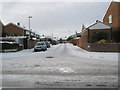
Looking from Lower Drayton Lane into Racton Avenue
Image: © Basher Eyre
Taken: 9 Jan 2010
0.06 miles
7
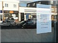
Drayton: ?Save Our Post Office?
A poster on a shop window invites readers to sign a petition to save Drayton's post office, which is reflected in the window and also shown here: Image
Image: © Chris Downer
Taken: 1 Dec 2007
0.07 miles
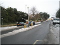
8
Bus stop at very top of Lower Drayton Lane
Image: © Basher Eyre
Taken: 28 Apr 2008
0.07 miles