IMAGES TAKEN NEAR TO
Lower Drayton Lane, PORTSMOUTH, PO6 2HD
Introduction
This page details the photographs taken nearby to Lower Drayton Lane, PO6 2HD by members of the Geograph project.
The Geograph project started in 2005 with the aim of publishing, organising and preserving representative images for every square kilometre of Great Britain, Ireland and the Isle of Man.

There are currently over 7.5m images from over14,400 individuals and you can help contribute to the project by visiting https://www.geograph.org.uk
Image Map
Images are licensed for reuse under creativecommons.org/licenses/by-sa/2.0
Notes
- Clicking on the map will re-center to the selected point.
- The higher the marker number, the further away the image location is from the centre of the postcode.
Image Listing (141 Images Found)
Images are licensed for reuse under creativecommons.org/licenses/by-sa/2.0
Image
Details
Distance
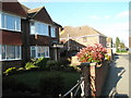
2
Impressive building in Dysart Avenue
Now converted into six flats
Image: © Basher Eyre
Taken: 4 Mar 2008
0.03 miles
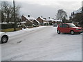
3
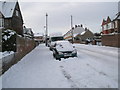
Cars heading west down a treacherous Dysart Avenue
Image: © Basher Eyre
Taken: 9 Jan 2010
0.03 miles
4
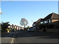
Looking southwards down Lower Drayton Lane
Image: © Basher Eyre
Taken: 28 Apr 2008
0.03 miles
5
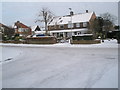
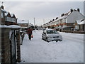
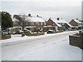
A snowy scene at the junction of Dysart Avenue and Lower Drayton Lane
Image: © Basher Eyre
Taken: 9 Jan 2010
0.04 miles
6
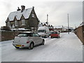
Red car turning from Lower Drayton Road into Dysart Avenue
Image: © Basher Eyre
Taken: 9 Jan 2010
0.04 miles
7
Eastern end of Dysart Avenue at its junction with Lower Drayton Lane
Image: © Basher Eyre
Taken: 28 Apr 2008
0.04 miles
9
Looking from Dysart Avenue into Lower Drayton Lane
Image: © Basher Eyre
Taken: 9 Jan 2010
0.04 miles