IMAGES TAKEN NEAR TO
Penrhyn Avenue, PORTSMOUTH, PO6 2AX
Introduction
This page details the photographs taken nearby to Penrhyn Avenue, PO6 2AX by members of the Geograph project.
The Geograph project started in 2005 with the aim of publishing, organising and preserving representative images for every square kilometre of Great Britain, Ireland and the Isle of Man.

There are currently over 7.5m images from over14,400 individuals and you can help contribute to the project by visiting https://www.geograph.org.uk
Image Map
Images are licensed for reuse under creativecommons.org/licenses/by-sa/2.0
Notes
- Clicking on the map will re-center to the selected point.
- The higher the marker number, the further away the image location is from the centre of the postcode.
Image Listing (174 Images Found)
Images are licensed for reuse under creativecommons.org/licenses/by-sa/2.0
Image
Details
Distance
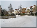
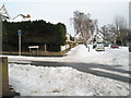
1
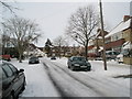
Looking northwards up a snowy Penrhyn Avenue
Image: © Basher Eyre
Taken: 9 Jan 2010
0.02 miles
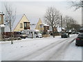
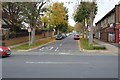
4
Approaching the junction of Penrhyn Avenue and Aberdare Avenue
Image: © Basher Eyre
Taken: 9 Jan 2010
0.04 miles
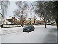
5
Looking from Penrhyn Avenue into Aberdare Avenue
Image: © Basher Eyre
Taken: 9 Jan 2010
0.05 miles
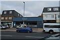
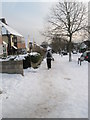
9
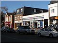
Drayton: the post office
This branch is proposed for closure in January 2008, the nearest alternatives being Cosham, a mile or so west, and Farlington, slightly closer east. See also Image
Image: © Chris Downer
Taken: 1 Dec 2007
0.07 miles
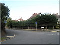
10
Junction of a snowy Penrhyn Avenue and Merthyr Avenue
Image: © Basher Eyre
Taken: 9 Jan 2010
0.07 miles