IMAGES TAKEN NEAR TO
Landguard Caravan Park, Landguard Manor Road, SHANKLIN, PO37 7PJ
Introduction
This page details the photographs taken nearby to Landguard Caravan Park, Landguard Manor Road, PO37 7PJ by members of the Geograph project.
The Geograph project started in 2005 with the aim of publishing, organising and preserving representative images for every square kilometre of Great Britain, Ireland and the Isle of Man.

There are currently over 7.5m images from over14,400 individuals and you can help contribute to the project by visiting https://www.geograph.org.uk
Image Map
Images are licensed for reuse under creativecommons.org/licenses/by-sa/2.0
Notes
- Clicking on the map will re-center to the selected point.
- The higher the marker number, the further away the image location is from the centre of the postcode.
Image Listing (13 Images Found)
Images are licensed for reuse under creativecommons.org/licenses/by-sa/2.0
Image
Details
Distance
1

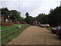
Landguard Holiday Camp IOW
Fields on the edge of the camp
Image: © norman griffin
Taken: 11 May 1982
0.07 miles
2
It's holiday time
Landguard holiday park. Lodges aka mobile homes on a damp late September day.
Image: © Anthony Vosper
Taken: 29 Sep 2017
0.08 miles
3
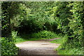
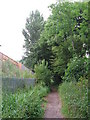
Along the Byway, Landguard, Isle of Wight
On the outskirts of Shanklin, a byway runs north-south, and a bridleway runs east-west. The route, behind the photographer, runs to Shanklin Station; some half a mile distant. A caravan park lies, just out of picture, to the right.
Image: © Peter Trimming
Taken: 13 Jun 2012
0.09 miles
4
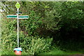
Crossing of the Ways, Landguard, Isle of Wight
On the outskirts of Shanklin, a byway runs north-south, and a bridleway runs east-west. The route, behind the photographer, runs to Shanklin Station; some half a mile distant. A caravan park lies, just out of picture, to the right.
Image: © Peter Trimming
Taken: 13 Jun 2012
0.09 miles
5
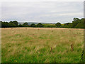
Field near Ninham Farm
Amidst all the camping sites and holiday parks within this square is a fallow field reminding you of the agricultural activities that still take place, the field to the south of this image was growing corn too. Taken from Whitecross Lane.
Image: © Simon Carey
Taken: 28 Jul 2007
0.16 miles
6
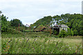
Derelict shed, Shanklin
It appears to have had an integral lean-to section on the far side. Purpose unknown.
Image: © Robin Webster
Taken: 19 Aug 2017
0.19 miles
7
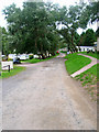
Lower Hyde Holiday Park
On the outskirts of Shanklin. Both a public byway and bridleway go through the camp, looking south down the track at the junction with the bridleway.
Image: © Simon Carey
Taken: 28 Jul 2007
0.21 miles
9
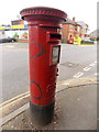
Shanklin: postbox № PO37 95, Green Lane
A very rare specimen from the short reign of Edward VIII, unfortunately daubed in graffiti on this side. It faces a hedge on a narrow pavement so it is not possible to view the whole box from any further round than this.
See Image for a close-up of the cipher.
Image: © Chris Downer
Taken: 20 Mar 2014
0.23 miles
10
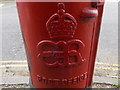
Shanklin: an Edward VIII postbox cipher
Detail of Image, showing the cipher of Edward VIII. Due to his short reign only around 160 boxes were made with this cipher, and only around 80 survive today. This is one of two on the Isle of Wight.
Image: © Chris Downer
Taken: 20 Mar 2014
0.23 miles