IMAGES TAKEN NEAR TO
Landguard Road, SHANKLIN, PO37 7HT
Introduction
This page details the photographs taken nearby to Landguard Road, PO37 7HT by members of the Geograph project.
The Geograph project started in 2005 with the aim of publishing, organising and preserving representative images for every square kilometre of Great Britain, Ireland and the Isle of Man.

There are currently over 7.5m images from over14,400 individuals and you can help contribute to the project by visiting https://www.geograph.org.uk
Image Map
Images are licensed for reuse under creativecommons.org/licenses/by-sa/2.0
Notes
- Clicking on the map will re-center to the selected point.
- The higher the marker number, the further away the image location is from the centre of the postcode.
Image Listing (263 Images Found)
Images are licensed for reuse under creativecommons.org/licenses/by-sa/2.0
Image
Details
Distance
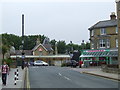
2
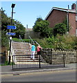
Steps up to Shanklin railway station from two trails
From the northern end of Landguard Road, near the southern end of Landguard Manor Road.
The blue sign pointing left shows SUNSHINE TRAIL Lake 1.5 (miles) Sandown 2.5.
The blue sign pointing right towards the town centre and Esplanade shows
RED SQUIRREL TRAIL and a white-on-red 23, indicating National Cycle Network Route 23.
Current red squirrel population estimates are 138,000 in the UK with 120,000 in Scotland, 3,000 in Wales and 15,000 in England of which 3,500 are here on the Isle of Wight. One estimate of the number of grey squirrels in the UK is 2.5 million. However, as there is no current method of comprehensively surveying grey squirrels, this could be a considerable underestimate.
Image: © Jaggery
Taken: 22 Aug 2015
0.03 miles
3
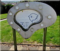
Sunshine Trail route map near Shanklin railway station
Located here. http://www.geograph.org.uk/photo/4628999
The Sunshine Trail is a 19km (12 mile) circular cycle route on the Isle of Wight. It includes a part of the Newport to Sandown National Cycle Network route 23 and new off-road links. The route is based around Sandown, Lake and Shanklin railway stations. The mainly flat route includes a challenging off-road section for mountain bikes.
Image: © Jaggery
Taken: 22 Aug 2015
0.03 miles
5
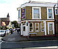
Hong Kong City in Shanklin
Chinese takeaway on the corner of Regent Street and Marine Cross Road.
Image: © Jaggery
Taken: 22 Aug 2015
0.03 miles
6
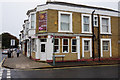
Hong Kong City takeaway on Regent Street, Shanklin
Image: © Ian S
Taken: 20 Aug 2015
0.03 miles
7
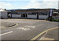
Shanklin railway station
The railway station at Shanklin on the Isle of Wight.
Image: © Malc McDonald
Taken: 25 Jun 2011
0.03 miles
8
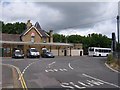
Railway Station - Shanklin
View of the station Approach.
Image: © Colin Babb
Taken: 23 Jun 2008
0.03 miles
9
Isle of Wight Textiles, Shanklin
Modern textile supplier at 62 Landguard Road.
Image: © Jaggery
Taken: 22 Aug 2015
0.03 miles
10
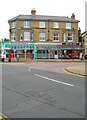
Parade of Shops, Atherley Road
On the junction with Regent Street next to the station.
Image: © Simon Carey
Taken: 28 Jul 2007
0.03 miles