IMAGES TAKEN NEAR TO
Ackworth Road, PORTSMOUTH, PO3 5NS
Introduction
This page details the photographs taken nearby to Ackworth Road, PO3 5NS by members of the Geograph project.
The Geograph project started in 2005 with the aim of publishing, organising and preserving representative images for every square kilometre of Great Britain, Ireland and the Isle of Man.

There are currently over 7.5m images from over14,400 individuals and you can help contribute to the project by visiting https://www.geograph.org.uk
Image Map
Images are licensed for reuse under creativecommons.org/licenses/by-sa/2.0
Notes
- Clicking on the map will re-center to the selected point.
- The higher the marker number, the further away the image location is from the centre of the postcode.
Image Listing (60 Images Found)
Images are licensed for reuse under creativecommons.org/licenses/by-sa/2.0
Image
Details
Distance
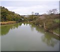
1
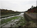
Ports Creek
All that separates Portsea Island from the mainland.
Image: © Jonathan Thacker
Taken: 29 Oct 2016
0.10 miles
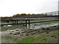
4
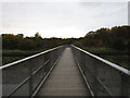
Footbridge over Ports Creek
Looking towards Hilsea Lines.
Image: © Jonathan Thacker
Taken: 29 Oct 2016
0.11 miles
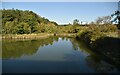
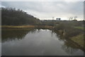
6
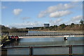
Railway crossing the Ports Creek near Cosham
Image: © Roy Hughes
Taken: 17 Jul 2021
0.11 miles
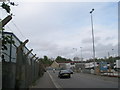
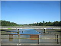
8
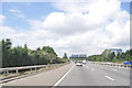
Portsmouth : The A27
The A27 heading towards the M27 motorway.
Image: © Lewis Clarke
Taken: 23 Jul 2010
0.13 miles