IMAGES TAKEN NEAR TO
Quarr Place, RYDE, PO33 4EW
Introduction
This page details the photographs taken nearby to Quarr Place, PO33 4EW by members of the Geograph project.
The Geograph project started in 2005 with the aim of publishing, organising and preserving representative images for every square kilometre of Great Britain, Ireland and the Isle of Man.

There are currently over 7.5m images from over14,400 individuals and you can help contribute to the project by visiting https://www.geograph.org.uk
Image Map
Images are licensed for reuse under creativecommons.org/licenses/by-sa/2.0
Notes
- Clicking on the map will re-center to the selected point.
- The higher the marker number, the further away the image location is from the centre of the postcode.
Image Listing (46 Images Found)
Images are licensed for reuse under creativecommons.org/licenses/by-sa/2.0
Image
Details
Distance
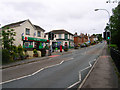
1
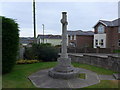
War memorial at the junction of Church Road and Binstead Hill
Image: © Basher Eyre
Taken: 17 Oct 2015
0.09 miles
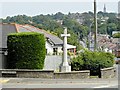
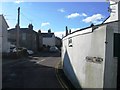
3
Junction of Church Road, Quarr Hill, Binstead Hill and Newnham Road
Image: © Basher Eyre
Taken: 17 Oct 2015
0.09 miles
5
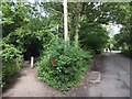
IOW coastal path sign in Binstead
The path has followed a track from Quarr and now follows a footpath through woodland.
Image: © David Smith
Taken: 17 Jun 2012
0.12 miles
6
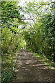
Coastal path through Pelhamfield
The Isle of Wight Coastal Path runs along here, on one of its inland sections. This is a popular local footpath west of Ryde.
Image: © Graham Horn
Taken: 1 May 2010
0.12 miles
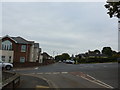
7

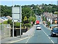
A3054 descending Binstead Hill beyond junction with Arnold Road
Image: © Stuart Logan
Taken: 12 Aug 2014
0.15 miles
9
Binstead Road, Binstead
Looking up the road toward the peak of Binstead Hill. The small village has been virtually swallowed by Ryde and become its suburb, modern postwar housing estates occupy the land south of the main road though the leafier lanes survive to the north. The road in view is the A3054 which links Ryde to Newport as well as the car ferries to Portsmouth at Fishbourne.
Image: © Simon Carey
Taken: 19 Aug 2007
0.16 miles