IMAGES TAKEN NEAR TO
The Hayloft, RYDE, PO33 3JE
Introduction
This page details the photographs taken nearby to The Hayloft, PO33 3JE by members of the Geograph project.
The Geograph project started in 2005 with the aim of publishing, organising and preserving representative images for every square kilometre of Great Britain, Ireland and the Isle of Man.

There are currently over 7.5m images from over14,400 individuals and you can help contribute to the project by visiting https://www.geograph.org.uk
Image Map
Images are licensed for reuse under creativecommons.org/licenses/by-sa/2.0
Notes
- Clicking on the map will re-center to the selected point.
- The higher the marker number, the further away the image location is from the centre of the postcode.
Image Listing (11 Images Found)
Images are licensed for reuse under creativecommons.org/licenses/by-sa/2.0
Image
Details
Distance
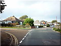
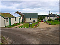
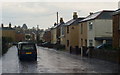
2
Caution, men at Work!
Well, you have to look carefully, but they are hiding in the white van, in the centre of picture. In all honesty, I could not blame them; a couple of minutes earlier, the rain started in earnest, and they had obviously been erecting the scaffolding, to the left of picture.
Seconds before taking this picture, there had been a violent flash; I heard the lightning strike, which was followed, a split second later, by a huge clap of thunder. I subsequently found that Aldermoor Farm, just two hundred yards south of this location, had been hit. Surely things could not get worse, as I trudged towards Ryde!
Image: © Peter Trimming
Taken: 12 Apr 2012
0.08 miles
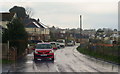
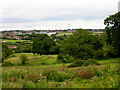
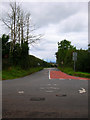
3
View From Upton Road, Upton, Isle of Wight
Photograph taken from Upton Road, beside the entrance to Aldermoor Farm. The view is across the outskirts of Ryde, towards Portsmouth.
The building, to the right of picture, is one of the outbuildings of Aldermoor Farm. The farmhouse lies just beyond the outbuildings. Heavy rain had just commenced falling, and, four minutes later (2.30pm), the farmhouse was struck by lightning.
http://www.iwcp.co.uk/news/news/lightning-hits-building-43887.aspx
Image: © Peter Trimming
Taken: 12 Apr 2012
0.14 miles
4
Upton Road, Upton, Isle of Wight
Looking in the direction of Ryde. In the distance, the tip of the Spinnaker Tower, at Portsmouth, can just be seen.
Image: © Peter Trimming
Taken: 12 Apr 2012
0.15 miles
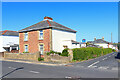
5
Aldermoor Farm
Farm on the outskirts of Ryde.
Image: © Wayland Smith
Taken: 13 Jun 2021
0.17 miles
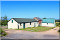
7
Aldermoor Farm
On the Upton Road between Ryde and Upton the farm seems to be home to other businesses most notably the Natural Therapy Centre for animals. Taken from the entrance on Upton Road.
Image: © Simon Carey
Taken: 19 Aug 2007
0.18 miles
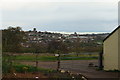
8
Outskirts of Ryde
Taken from Upton Road looking down into the valley that contains Monktonmead Brook and the railway line before rising again passing Ryde Business Park and heading into Oakfield.
Image: © Simon Carey
Taken: 19 Aug 2007
0.21 miles
9
Upton Road, Haylands, Isle of Wight
Looking towards Ryde, as torrential rain fell, during a thunder storm. The thunder set off several car alarms.
Image: © Peter Trimming
Taken: 12 Apr 2012
0.24 miles
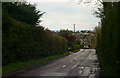
10
Upton Road, Upton
Taking from the crossroads at Upton looking towards Ryde whose All Saints church tower can be seen on the horizon.
Image: © Simon Carey
Taken: 19 Aug 2007
0.24 miles