IMAGES TAKEN NEAR TO
Ryde House Drive, RYDE, PO33 3FE
Introduction
This page details the photographs taken nearby to Ryde House Drive, PO33 3FE by members of the Geograph project.
The Geograph project started in 2005 with the aim of publishing, organising and preserving representative images for every square kilometre of Great Britain, Ireland and the Isle of Man.

There are currently over 7.5m images from over14,400 individuals and you can help contribute to the project by visiting https://www.geograph.org.uk
Image Map
Images are licensed for reuse under creativecommons.org/licenses/by-sa/2.0
Notes
- Clicking on the map will re-center to the selected point.
- The higher the marker number, the further away the image location is from the centre of the postcode.
Image Listing (16 Images Found)
Images are licensed for reuse under creativecommons.org/licenses/by-sa/2.0
Image
Details
Distance
1
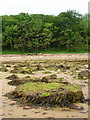
Shoreline near Ryde House
Looking towards the small piece of land that juts out into the square from the beach at low tide. The wood is private property and has no access.
Image: © Simon Carey
Taken: 19 Aug 2007
0.10 miles
2
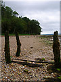
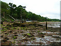
Shoreline near Ryde House
Looking through the remains of an old jetty at the unspoilt shoreline between Ryde and Fishbourne where the woods quite literally end at the beach.
Image: © Simon Carey
Taken: 19 Aug 2007
0.10 miles
3
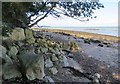
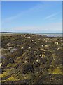
Limestone outcrop west of Ryde
The short stretch of land along the southern edge of this square includes an exposed outcrop of Binstead limestone. In the 11th century, stone like this from quarries nearby was used to build Winchester Cathedral.
Image: © Paul Coueslant
Taken: 13 Sep 2017
0.11 miles
4
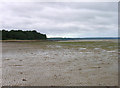
Ryde West Sands
A small piece of the wooded headland juts out into this square. Ryde West Sands is a mixture of sand, shingle and mud and stretches along to Binstead Hard.
Image: © Simon Carey
Taken: 19 Aug 2007
0.11 miles
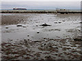
5
Exposed rocks west of Ryde
Low tide reveals this seaweed-strewn line of rocks around 25 metres from the shoreline.
Image: © Paul Coueslant
Taken: 13 Sep 2017
0.14 miles
6
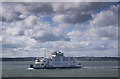
Ferry Ryde
Car ferry out of Fishbourne, Isle of Wight, en route to Portsmouth passing Ryde with the spire of All Saints Church clearly discernible in the background.
Image: © Kurseong Carl
Taken: 30 Aug 2012
0.16 miles
7
Boathouse near Binstead Hard
There are what appears to be a decayed concrete sea wall or jetty before that.
Image: © Simon Carey
Taken: 19 Aug 2007
0.19 miles
8
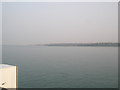
As seen from St Faith's Car Ferry (3)
Looking towards Ryde.
Image: © Basher Eyre
Taken: 27 Mar 2011
0.19 miles
10
Ryde West Sands
Looking out onto the beach at low tide with a large container vessel travelling through The Solent, though the water immediately beyond the beach is known as Ryde Roads.
Image: © Simon Carey
Taken: 19 Aug 2007
0.21 miles