IMAGES TAKEN NEAR TO
PO19 2LR
Introduction
This page details the photographs taken nearby to PO19 2LR by members of the Geograph project.
The Geograph project started in 2005 with the aim of publishing, organising and preserving representative images for every square kilometre of Great Britain, Ireland and the Isle of Man.

There are currently over 7.5m images from over14,400 individuals and you can help contribute to the project by visiting https://www.geograph.org.uk
Image Map
Images are licensed for reuse under creativecommons.org/licenses/by-sa/2.0
Notes
- Clicking on the map will re-center to the selected point.
- The higher the marker number, the further away the image location is from the centre of the postcode.
Image Listing (283 Images Found)
Images are licensed for reuse under creativecommons.org/licenses/by-sa/2.0
Image
Details
Distance
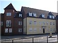
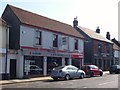
2
The Hornet, Chichester
Modern apartment buildings by the entrance to St Agnes Place.
Image: © David960
Taken: 18 May 2014
0.04 miles
3
The Hornet, Chichester, Sussex
Looking towards Chichester Cathedral, and the city centre.
Image: © Peter Trimming
Taken: 10 Dec 2011
0.07 miles
4
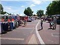
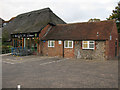
Wednesday Market - Chichester
It seemed to be doing a brisk trade. Bought myself a pair of slippers, very reasonably priced. A bit sad, I suppose.
Image: © Colin Babb
Taken: 16 Jul 2008
0.07 miles
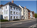
5
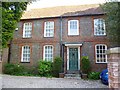
The Old Manse
In The Hornet, Chichester. Grade II listed: http://www.britishlistedbuildings.co.uk/en-299937-98-the-hornet-chichester-west-sussex
Image: © David960
Taken: 18 May 2014
0.07 miles
6
Majestic Wine Warehouse
On the corner of The Hornet and Needlemakers
Image: © Nick Smith
Taken: 4 Oct 2011
0.08 miles
7
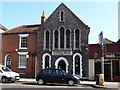
Jasmine House
Former chapel in The Hornet, Chichester. Number 30 on the left is Grade II listed: http://www.britishlistedbuildings.co.uk/en-29993330-the-hornet-chichester-west-sussex-
Image: © David960
Taken: 18 May 2014
0.08 miles
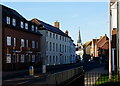
8
St Pancras
This is the A285 which follows Stane Street, the old Roman route out of the city. The road already had a considerable suburb along during medieval times but was part demolished in 1642 during the Civil War siege of the city only returning to prominence during Georgian times when many townhouses were built along the route. This view is opposite Litten Gardens and the road here is part of a gyratory system out of the city.
Image: © Simon Carey
Taken: 20 Jan 2008
0.10 miles
9
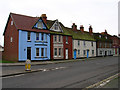
Two ex-pubs in The Hornet, Chichester
C.M.W. Motorcycles was the Half Moon, Clothkits was the Bush.
Image: © David960
Taken: 18 May 2014
0.10 miles
10
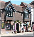
Chichester : Almshouse Arcade
"Late 19th century building previously known as “Deans Almshouses” which provided dwellings to elderly Cicestrians." - https://www.chichester.gov.uk/media/9270/Hornet-The-19-Almshouse-Arcade/pdf/The_Hornet__19__Almshouse_Arcade.pdf
Image: © Jim Osley
Taken: 27 Aug 2021
0.10 miles