IMAGES TAKEN NEAR TO
All Saints Road, PORTSMOUTH, PO1 4EW
Introduction
This page details the photographs taken nearby to All Saints Road, PO1 4EW by members of the Geograph project.
The Geograph project started in 2005 with the aim of publishing, organising and preserving representative images for every square kilometre of Great Britain, Ireland and the Isle of Man.

There are currently over 7.5m images from over14,400 individuals and you can help contribute to the project by visiting https://www.geograph.org.uk
Image Map
Images are licensed for reuse under creativecommons.org/licenses/by-sa/2.0
Notes
- Clicking on the map will re-center to the selected point.
- The higher the marker number, the further away the image location is from the centre of the postcode.
Image Listing (160 Images Found)
Images are licensed for reuse under creativecommons.org/licenses/by-sa/2.0
Image
Details
Distance
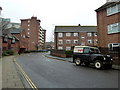
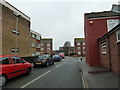
2
Looking from Victoria Street towards Brisbane Court
Image: © Basher Eyre
Taken: 19 Feb 2011
0.05 miles
5
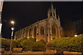
Church of All Saints'
Grade II listed. https://historicengland.org.uk/listing/the-list/list-entry/1387021
Image: © N Chadwick
Taken: 12 Jan 2019
0.06 miles
6
Looking from Nelson Road into Princes Street
Image: © Basher Eyre
Taken: 19 Feb 2011
0.06 miles
7
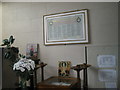
Memorial to the fallen at All Saints, Portsea
Image: © Basher Eyre
Taken: 12 Sep 2009
0.07 miles
8
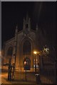
Church of All Saints'
Grade II listed. https://historicengland.org.uk/listing/the-list/list-entry/1387021
Image: © N Chadwick
Taken: 12 Jan 2019
0.07 miles
9
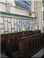
Choir stalls within All Saints, Portsea
Image: © Basher Eyre
Taken: 12 Sep 2009
0.07 miles
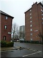
10
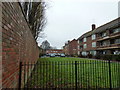
Green between Princes Court, Regents Court and Victoria Street
Image: © Basher Eyre
Taken: 19 Feb 2011
0.07 miles