IMAGES TAKEN NEAR TO
Southampton Hill, FAREHAM, PO14 4GA
Introduction
This page details the photographs taken nearby to Southampton Hill, PO14 4GA by members of the Geograph project.
The Geograph project started in 2005 with the aim of publishing, organising and preserving representative images for every square kilometre of Great Britain, Ireland and the Isle of Man.

There are currently over 7.5m images from over14,400 individuals and you can help contribute to the project by visiting https://www.geograph.org.uk
Image Map
Images are licensed for reuse under creativecommons.org/licenses/by-sa/2.0
Notes
- Clicking on the map will re-center to the selected point.
- The higher the marker number, the further away the image location is from the centre of the postcode.
Image Listing (270 Images Found)
Images are licensed for reuse under creativecommons.org/licenses/by-sa/2.0
Image
Details
Distance
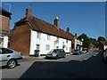
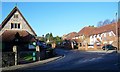
2
Southampton Hill - Titchfield
Looking up Southampton Hill at its junction with East Street and High Street.
Image: © Colin Babb
Taken: 19 May 2011
0.02 miles
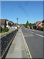
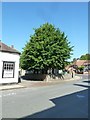
3
Bottom of Southampton Hill- Titchfield
New houses on the right blend in quite well.
Image: © Colin Babb
Taken: 4 Dec 2006
0.02 miles
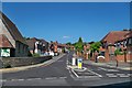
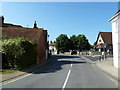
4
Looking from High Street into Southampton Hill
Image: © Basher Eyre
Taken: 3 Jun 2011
0.02 miles

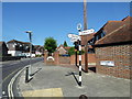
7
Junction of High Street and Southampton Hill
Image: © Basher Eyre
Taken: 3 Jun 2011
0.03 miles
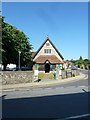
8
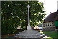
War Memorial next to Titchfield Parish Room
Image: © Barry Shimmon
Taken: 26 Sep 2009
0.04 miles