IMAGES TAKEN NEAR TO
South Hill, PLYMOUTH, PL9 9PX
Introduction
This page details the photographs taken nearby to South Hill, PL9 9PX by members of the Geograph project.
The Geograph project started in 2005 with the aim of publishing, organising and preserving representative images for every square kilometre of Great Britain, Ireland and the Isle of Man.

There are currently over 7.5m images from over14,400 individuals and you can help contribute to the project by visiting https://www.geograph.org.uk
Image Map
Images are licensed for reuse under creativecommons.org/licenses/by-sa/2.0
Notes
- Clicking on the map will re-center to the selected point.
- The higher the marker number, the further away the image location is from the centre of the postcode.
Image Listing (19 Images Found)
Images are licensed for reuse under creativecommons.org/licenses/by-sa/2.0
Image
Details
Distance
2
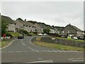
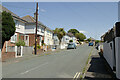
South Hill, Hooe
Post-WW2 council housing estate.
Image: © Alan Murray-Rust
Taken: 28 Jun 2023
0.12 miles
3
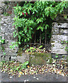
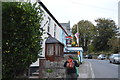
Old Wayside Cross by Belle Vue Road
Hooe Manor Cross, old base by the UC road, in parish of Plymouth (Plymouth District), Belle Vue Road, a lane to the entrance of Hooe Manor, built into a stone wall opposite the entrance to the manor but with a gap filled by railings over the stone so that it is visible.
Surveyed
Milestone Society National ID: DVPL_PLY06
Image: © Alan Rosevear
Taken: 27 Jun 2011
0.13 miles
4
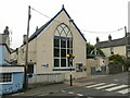
Hooe Baptist Chapel
Going back probably to the middle of the 19th century.
Image: © Alan Murray-Rust
Taken: 28 Jun 2023
0.16 miles
5
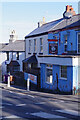
The Victoria Inn, Hooe
It would be easy to pass this pub without noticing it, so well does it blend in with the other buildings on Hooe Road, which is perhaps why it has been painted in a startling shade of blue.
Image: © Stephen McKay
Taken: 26 Feb 2023
0.17 miles
6
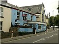
Victoria Inn, Hooe
One of two pubs from before the development of the village as a suburb of Plymouth.
Image: © Alan Murray-Rust
Taken: 28 Jun 2023
0.17 miles
10
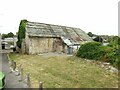
Hooe Barn
The barn dates from the 17th/18th century and formed part of the former manor house complex. Clearly in deteriorating condition. Listed Grade II.
Image: © Alan Murray-Rust
Taken: 27 Jun 2023
0.21 miles