IMAGES TAKEN NEAR TO
Hooe Road, PLYMOUTH, PL9 9NS
Introduction
This page details the photographs taken nearby to Hooe Road, PL9 9NS by members of the Geograph project.
The Geograph project started in 2005 with the aim of publishing, organising and preserving representative images for every square kilometre of Great Britain, Ireland and the Isle of Man.

There are currently over 7.5m images from over14,400 individuals and you can help contribute to the project by visiting https://www.geograph.org.uk
Image Map
Images are licensed for reuse under creativecommons.org/licenses/by-sa/2.0
Notes
- Clicking on the map will re-center to the selected point.
- The higher the marker number, the further away the image location is from the centre of the postcode.
Image Listing (18 Images Found)
Images are licensed for reuse under creativecommons.org/licenses/by-sa/2.0
Image
Details
Distance
1
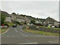
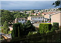
South Hill, Hooe
Post-WW2 council housing estate.
Image: © Alan Murray-Rust
Taken: 28 Jun 2023
0.05 miles
3
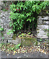
Old Wayside Cross by Belle Vue Road
Hooe Manor Cross, old base by the UC road, in parish of Plymouth (Plymouth District), Belle Vue Road, a lane to the entrance of Hooe Manor, built into a stone wall opposite the entrance to the manor but with a gap filled by railings over the stone so that it is visible.
Surveyed
Milestone Society National ID: DVPL_PLY06
Image: © Alan Rosevear
Taken: 27 Jun 2011
0.09 miles
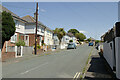
4
Reddicliff Road, Hooe
Late 20th century housing development
Image: © Alan Murray-Rust
Taken: 28 Jun 2023
0.12 miles
5
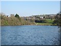
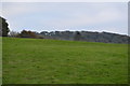
Radford Lake in Plymstock
This used to be an area of tidal mudflats but was dammed to form a freshwater lake. It is surrounded by suburban housing.
Image: © Tony Atkin
Taken: 15 Feb 2003
0.18 miles
6
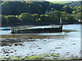
Hulk, Hooe Lake
Within the eastern end of Hooe Lake are the remnants of a number of old 'hulks' abandoned during the early part of the 20th century. Beyond and behind the first line of trees upon the shore is the local sewage works, with the sludge loading point immediately behind the bow of the hulk.
Image: © Gwyn Jones
Taken: 13 Oct 2005
0.18 miles
8
Housing, Hooe
With modern housing on Reddicliff Road, seen from a footpath from Staddiscombe.
Image: © Derek Harper
Taken: 1 Jul 2011
0.19 miles
10
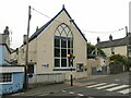
Hooe Baptist Chapel
Going back probably to the middle of the 19th century.
Image: © Alan Murray-Rust
Taken: 28 Jun 2023
0.22 miles