IMAGES TAKEN NEAR TO
Dean Hill, PLYMOUTH, PL9 9AE
Introduction
This page details the photographs taken nearby to Dean Hill, PL9 9AE by members of the Geograph project.
The Geograph project started in 2005 with the aim of publishing, organising and preserving representative images for every square kilometre of Great Britain, Ireland and the Isle of Man.

There are currently over 7.5m images from over14,400 individuals and you can help contribute to the project by visiting https://www.geograph.org.uk
Image Map
Images are licensed for reuse under creativecommons.org/licenses/by-sa/2.0
Notes
- Clicking on the map will re-center to the selected point.
- The higher the marker number, the further away the image location is from the centre of the postcode.
Image Listing (90 Images Found)
Images are licensed for reuse under creativecommons.org/licenses/by-sa/2.0
Image
Details
Distance
2
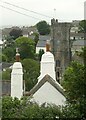
Chimneys and church tower, Plymstock
The chimneys belong to Burrow Farmhouse which dates from around 1600, Listed grade II. The rounded chimney stacks are typical of the area.
Image: © Alan Murray-Rust
Taken: 28 Jun 2023
0.06 miles
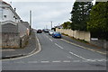
5
Louville and Marchant House, Church Road, Plymstock
Both houses date from the 18th century and are Listed Grade II. Of interest are the Venetian window in the gable of Louville and the traditional slate-hanging on Marchant House.
Image: © Alan Murray-Rust
Taken: 28 Jun 2023
0.09 miles
8
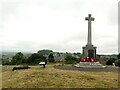
Burrow Hill
Recreating this 'First' for the square https://www.geograph.org.uk/photo/55972 . The mound on which the cross stands is a Late Bronze Age bowl barrow which is a Scheduled Monument.
Image: © Alan Murray-Rust
Taken: 28 Jun 2023
0.12 miles
9
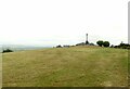
The top of Burrow Hill
This is a significant local high point and it is not surprising to find it chosen in the Late Bronze Age as the site of a funeral mound in the form of a bowl barrow. This was perpetuated in the 20th century by installing a WWI war memorial cross. The barrow is a Scheduled Monument. Could the name 'Burrow Hill' be a corruption of 'Barrow Hill'?
Image: © Alan Murray-Rust
Taken: 28 Jun 2023
0.12 miles