IMAGES TAKEN NEAR TO
Fletcher Way, PLYMOUTH, PL9 8LG
Introduction
This page details the photographs taken nearby to Fletcher Way, PL9 8LG by members of the Geograph project.
The Geograph project started in 2005 with the aim of publishing, organising and preserving representative images for every square kilometre of Great Britain, Ireland and the Isle of Man.

There are currently over 7.5m images from over14,400 individuals and you can help contribute to the project by visiting https://www.geograph.org.uk
Image Map
Images are licensed for reuse under creativecommons.org/licenses/by-sa/2.0
Notes
- Clicking on the map will re-center to the selected point.
- The higher the marker number, the further away the image location is from the centre of the postcode.
Image Listing (13 Images Found)
Images are licensed for reuse under creativecommons.org/licenses/by-sa/2.0
Image
Details
Distance
1

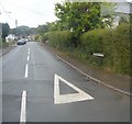
Furzehatt Avenue, Plymstock
A little further up the hill shown in Image On the left just up ahead is the turn into Furzehatt Rise.
Image: © Derek Harper
Taken: 1 Jul 2011
0.07 miles
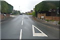
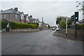
3

Plymstock: Charnhill Way
Looking towards Wembury Road
Image: © Martin Bodman
Taken: 27 Jun 2010
0.11 miles
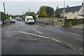
7
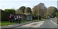
Bus stop, Wembury Road, Elburton
The bus shelter serves the service from Wembury to Plymouth
Image: © David Smith
Taken: 16 Apr 2015
0.14 miles
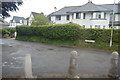
8
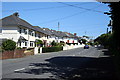
Semi-detached Houses along Furzehatt Road
Image: © Tony Atkin
Taken: 26 Jul 2008
0.15 miles
10
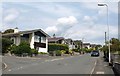
Furzehatt Avenue, Plymstock
Smart houses at the junction with Furzehatt Way (left).
Image: © Derek Harper
Taken: 1 Jul 2011
0.18 miles