IMAGES TAKEN NEAR TO
Chapel Road, PLYMOUTH, PL8 2LZ
Introduction
This page details the photographs taken nearby to Chapel Road, PL8 2LZ by members of the Geograph project.
The Geograph project started in 2005 with the aim of publishing, organising and preserving representative images for every square kilometre of Great Britain, Ireland and the Isle of Man.

There are currently over 7.5m images from over14,400 individuals and you can help contribute to the project by visiting https://www.geograph.org.uk
Image Map (Loading...)


Getting Data...Please wait
Leaflet Map data © OpenStreetMap
Images are licensed for reuse under creativecommons.org/licenses/by-sa/2.0
Notes
- Clicking on the map will re-center to the selected point.
- The higher the marker number, the further away the image location is from the centre of the postcode.
Image Listing (38 Images Found)
Images are licensed for reuse under creativecommons.org/licenses/by-sa/2.0
Image
Details
Distance
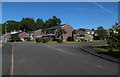
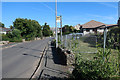
2
Bus stop and Methodist church in Yealmpton
On the road to Newton Ferrers; the building is marked as parish rooms on old maps
Image: © David Smith
Taken: 17 Jul 2015
0.08 miles
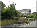
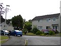
3
Modern housing estate, Yealmpton
Some of the more recent new houses in Yealmpton village on the valley floor near the river Yealm. The old village centre itself is situated a little way above the flood plain.
Image: © Tony Atkin
Taken: 6 Sep 2005
0.10 miles
4
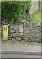
Old Bridge Marker on the B3186 in Yealmpton
County Bridge Marker built into a stone wall off the ground and next to a fire hydrant on the west side of the B3186 Torr Hill 100 metres south of Torr Bridge, River Yealm. Yealmpton parish. Inscribed C to mark the extent of roadway adjoining the bridge that the County was obliged to maintain.
Milestone Society National ID: DV_TNPL16br
Image: © T Jenkinson
Taken: 29 Apr 2010
0.10 miles
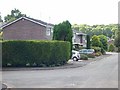
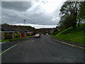
6
Bus stop on Ford Road, Yealmpton
With an open area fenced off.
Image: © Hugh Venables
Taken: 5 Jul 2019
0.12 miles
7
Rockdale Road, Yealmpton
Part of the post-WW2 expansion of the village to the south
Image: © David Smith
Taken: 17 Jul 2015
0.12 miles
9
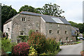
Yealmpton: Yealmpton Mills
A conversion to residential accommodation, with a further conversion – the old stable block – beyond. In 1866 the mill was offered to let: ‘.. old established and valuable Flour Mills known as the Yealmpton Mills, situated close to the village in the parish of Yealmpton, comprising three pairs of stones, driven by two water-wheels and having all necessary machinery .. for carrying on an extensive flour trade .. one mile from Kitley Quay where corn can be brought by water ..’ [Source: The Western Times 6 July 1866 p 1 col 1]. This was the lowest mill in the Yealm valley, powered by a leat from the river. A mill was known as ‘Mills’ when more than one waterwheel was employed
Image: © Martin Bodman
Taken: 10 Jul 2008
0.16 miles
10
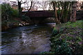
Bridges over the River Yealm
The road bridge carrying the B3186 over the Yealm is partially hidden by the separate pedestrian footbridge.
Image: © jeff collins
Taken: 7 Jan 2015
0.16 miles