IMAGES TAKEN NEAR TO
Nethecombe, Holbeton, PLYMOUTH, PL8 1LE
Introduction
This page details the photographs taken nearby to PL8 1LE by members of the Geograph project.
The Geograph project started in 2005 with the aim of publishing, organising and preserving representative images for every square kilometre of Great Britain, Ireland and the Isle of Man.

There are currently over 7.5m images from over14,400 individuals and you can help contribute to the project by visiting https://www.geograph.org.uk
Image Map
Images are licensed for reuse under creativecommons.org/licenses/by-sa/2.0
Notes
- Clicking on the map will re-center to the selected point.
- The higher the marker number, the further away the image location is from the centre of the postcode.
Image Listing (5 Images Found)
Images are licensed for reuse under creativecommons.org/licenses/by-sa/2.0
Image
Details
Distance
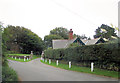
1
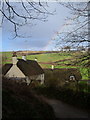
Rainbow over Nethecombe
A tiny hamlet of thatched cottages in a valley north of Mothecombe.
Image: © Derek Harper
Taken: 9 Dec 2006
0.04 miles
2
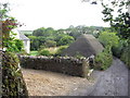
Hamlet with a thatched barn, near Mothecombe
Image: © Maurice D Budden
Taken: 21 Jul 2010
0.04 miles
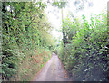
3
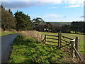
Mothecombe Lodge
The lane drops past Higher Field Plantation on the left, to the junction beside the lodge with the lane to Nethecombe. The land is part of the Flete estate; note new gate and fence.
Image: © Derek Harper
Taken: 9 Dec 2006
0.18 miles