IMAGES TAKEN NEAR TO
Newton Ferrers, PLYMOUTH, PL8 1JA
Introduction
This page details the photographs taken nearby to PL8 1JA by members of the Geograph project.
The Geograph project started in 2005 with the aim of publishing, organising and preserving representative images for every square kilometre of Great Britain, Ireland and the Isle of Man.

There are currently over 7.5m images from over14,400 individuals and you can help contribute to the project by visiting https://www.geograph.org.uk
Image Map
Images are licensed for reuse under creativecommons.org/licenses/by-sa/2.0
Notes
- Clicking on the map will re-center to the selected point.
- The higher the marker number, the further away the image location is from the centre of the postcode.
Image Listing (5 Images Found)
Images are licensed for reuse under creativecommons.org/licenses/by-sa/2.0
Image
Details
Distance
1
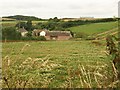
Newton Downs
An equestrian centre based at a farm just outside Newton Ferrers, set in the Shortaflete valley which runs down to the nearby River Yealm estuary. Seen from the lane to Wrescombe.
Image: © Derek Harper
Taken: 17 Jul 2008
0.03 miles
2
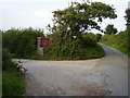
Junction at Newton Downs
Access to the local riding school.
Image: © Anthony Vosper
Taken: 4 Sep 2010
0.09 miles
3
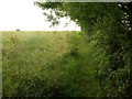
Footpath near Newton Downs
Newton and Noss Footpath 4 follows the edge of this field towards the B3186.
Image: © Derek Harper
Taken: 17 Jul 2008
0.12 miles
4
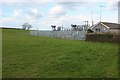
Electricity substation near Newton Ferrers
Seen from a gateway on the lane past Wrescombe.
Image: © Derek Harper
Taken: 5 Mar 2016
0.13 miles
5
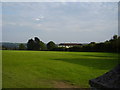
Butts Park football Pitch
Bathed in a late summer's sunshine.
Image: © Anthony Vosper
Taken: 4 Sep 2010
0.18 miles