IMAGES TAKEN NEAR TO
Plympton, PLYMOUTH, PL7 5EW
Introduction
This page details the photographs taken nearby to PL7 5EW by members of the Geograph project.
The Geograph project started in 2005 with the aim of publishing, organising and preserving representative images for every square kilometre of Great Britain, Ireland and the Isle of Man.

There are currently over 7.5m images from over14,400 individuals and you can help contribute to the project by visiting https://www.geograph.org.uk
Image Map
Images are licensed for reuse under creativecommons.org/licenses/by-sa/2.0
Notes
- Clicking on the map will re-center to the selected point.
- The higher the marker number, the further away the image location is from the centre of the postcode.
Image Listing (6 Images Found)
Images are licensed for reuse under creativecommons.org/licenses/by-sa/2.0
Image
Details
Distance
1
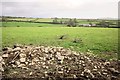
Faunstone Farm
From the same spot as Image], looking to the right, across the valley of a tributary of the Plym.
Image: © Derek Harper
Taken: 1 Nov 2014
0.07 miles
2
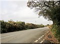
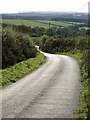
Road to the moor
A tiny lane from Coldstone Farm joins the road to Beatland Corner.
Image: © Derek Harper
Taken: 1 Nov 2014
0.16 miles
3
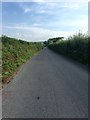
Minor road
Heading towards Beatland Corner, from Colebrook.
Image: © jeff collins
Taken: 11 Aug 2020
0.19 miles
4
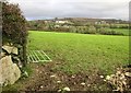
Farms near Kneel Gate
From the lane shown in Image, with Bugle Farm the nearest of the left, a large cluster of animal sheds beyond it, and Higher Bughill Farm (Bugle and Bughill doubtless variants of the same word) on the right. Image] looks to the right from the same spot.
Image: © Derek Harper
Taken: 1 Nov 2014
0.19 miles
5
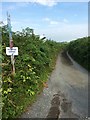
Port Lane
A narrow lane going towards Faunstone Farm. According to the sign, Faunstone Cottage is sale agreed.
Image: © jeff collins
Taken: 11 Aug 2020
0.20 miles
6
Lane to Faunstone
From near Higher Bughill Farm, a view down the lane shown in Image as it descends towards the Pethill valley.
Image: © Derek Harper
Taken: 8 Oct 2009
0.22 miles