IMAGES TAKEN NEAR TO
Plympton, PLYMOUTH, PL7 5ED
Introduction
This page details the photographs taken nearby to PL7 5ED by members of the Geograph project.
The Geograph project started in 2005 with the aim of publishing, organising and preserving representative images for every square kilometre of Great Britain, Ireland and the Isle of Man.

There are currently over 7.5m images from over14,400 individuals and you can help contribute to the project by visiting https://www.geograph.org.uk
Image Map
Images are licensed for reuse under creativecommons.org/licenses/by-sa/2.0
Notes
- Clicking on the map will re-center to the selected point.
- The higher the marker number, the further away the image location is from the centre of the postcode.
Image Listing (13 Images Found)
Images are licensed for reuse under creativecommons.org/licenses/by-sa/2.0
Image
Details
Distance
1
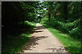
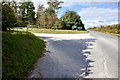
Cann Woods Footpath
Looking North, on the way to the car park at Cann Woods.
Image: © jeff collins
Taken: 20 Jun 2009
0.12 miles
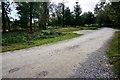
2
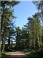
Woodland car park, Cann Wood
The car park at the eastern end of the wood, amongst tall larches.
Image: © Derek Harper
Taken: 8 Oct 2009
0.13 miles
3
Cann Wood
This path, not far from Boringdon Camp, is heading towards the road down the east side of the wood, a little south of the car park.
Image: © Derek Harper
Taken: 23 Jun 2014
0.13 miles
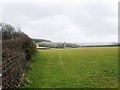
4
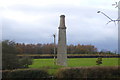
Wheal Sydney mine chimney
The chimney is a remnant of Wheal Sydney, a tin mine which was operational in the latter part of the 19th century. The photograph was taken from a bridleway known as Park Lane.
Image: © Nigel Mole
Taken: 14 Nov 2007
0.14 miles
5
Entrance to the parking area at Cann Woods
Just off the minor road between Colebrook and Beatland Corner.
Image: © jeff collins
Taken: 1 Oct 2018
0.15 miles
7
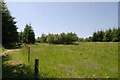
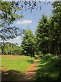
Field in Cann Wood
Field in Cann Wood, Plympton, Devon.
Image: © Kevin Hale
Taken: 17 Jun 2006
0.16 miles
9
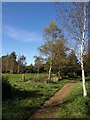
Path in Cann Wood
The path is leading across a clearing towards the picnic area at the east edge of Image
Image: © Derek Harper
Taken: 8 Oct 2009
0.17 miles
10
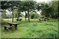
Sparkwell: picnic tables, Cann Wood
In a clearing by the public footpath from the car park on the Plympton-Shaugh Prior road to Boringdon Camp, which is nearby
Image: © Martin Bodman
Taken: 5 Aug 2010
0.20 miles