IMAGES TAKEN NEAR TO
Compass Drive, PLYMOUTH, PL7 5DX
Introduction
This page details the photographs taken nearby to Compass Drive, PL7 5DX by members of the Geograph project.
The Geograph project started in 2005 with the aim of publishing, organising and preserving representative images for every square kilometre of Great Britain, Ireland and the Isle of Man.

There are currently over 7.5m images from over14,400 individuals and you can help contribute to the project by visiting https://www.geograph.org.uk
Image Map
Images are licensed for reuse under creativecommons.org/licenses/by-sa/2.0
Notes
- Clicking on the map will re-center to the selected point.
- The higher the marker number, the further away the image location is from the centre of the postcode.
Image Listing (9 Images Found)
Images are licensed for reuse under creativecommons.org/licenses/by-sa/2.0
Image
Details
Distance
1
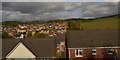
Highglen Drive and the bus shelter at its northern end
Not sure why a residential road in Devon should take the name of "Glen"
Image: © David Smith
Taken: 28 May 2016
0.09 miles
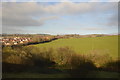
8
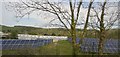
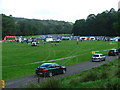
Newnham Park
Adjacent to Torry Brook and just off the Lee Moor Road, is Newnham Park; the photograph showing the 'meadow' which is frequently the focal point for a variety of activities ranging from mountain biking, carriage eventing through to trail running and music festivals, dependent on the time and date.
Image: © Gwyn Jones
Taken: 11 Sep 2005
0.22 miles
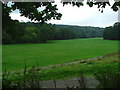
9
Newnham Park
Scene of the 'gathering' for the 2005 Autumn Trail - an eight mile offroad run in the woods of Newnham Estate.
Image: © Gwyn Jones
Taken: 25 Sep 2005
0.22 miles