IMAGES TAKEN NEAR TO
Drakelands, PLYMOUTH, PL7 5BS
Introduction
This page details the photographs taken nearby to PL7 5BS by members of the Geograph project.
The Geograph project started in 2005 with the aim of publishing, organising and preserving representative images for every square kilometre of Great Britain, Ireland and the Isle of Man.

There are currently over 7.5m images from over14,400 individuals and you can help contribute to the project by visiting https://www.geograph.org.uk
Image Map
Images are licensed for reuse under creativecommons.org/licenses/by-sa/2.0
Notes
- Clicking on the map will re-center to the selected point.
- The higher the marker number, the further away the image location is from the centre of the postcode.
Image Listing (17 Images Found)
Images are licensed for reuse under creativecommons.org/licenses/by-sa/2.0
Image
Details
Distance
1

Mumford Cottage
Approaching the cottage from the south in rain, on the track across Crownhill Down.
Image: © Derek Harper
Taken: 14 Jan 2007
0.01 miles
2

Tractor at Mumford Cottage
Taken a few yards north of the cottage. Crownhill Tor lurks on the low hill beyond the dilapidated barn.
Image: © Derek Harper
Taken: 14 Jan 2007
0.03 miles
3

Invisible path
Luckily the hole in the dry stone wall and stile give the game away. In the distance is part of the Headon China Clay Works.
Image: © jeff collins
Taken: 25 Jun 2014
0.06 miles
4
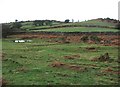
Towards Crownhill Tor
No tor is really visible, but it lurks beyond the bushes at the rop right. Taken from the track from Mumford Cottage to Ridding Down as it crosses rough ground approaching its junction with Cornwood Bridleway 27.
Image: © Derek Harper
Taken: 14 Jan 2007
0.07 miles
5
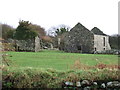
Broomage
Another view of Image from the opposite direction. The tall window on the right is the subject of Image
Image: © Derek Harper
Taken: 14 Jan 2007
0.10 miles
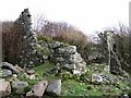
6
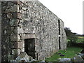
Broomage
See Image This view of the ruinous farmhouse shows the large quoin stones of the local pink granite, and a sturdy lintel.
Image: © Derek Harper
Taken: 14 Jan 2007
0.10 miles
7

Broomage
Looking through the windows of the derelict granite farmhouse building shown in Image
Image: © Derek Harper
Taken: 14 Jan 2007
0.11 miles
8

Ruined farm buildings close to Broomage Wood
Looking in a West southwesterly direction. The path behind my position goes down to Quick Bridge, the path to Lutton turns left.
Image: © jeff collins
Taken: 25 Jun 2014
0.11 miles
9
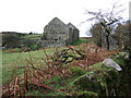
Broomage
The gable end walls are still intact, so this derelict Dartmoor farm has probably not been disused for many decades. Seen a few yards along Cornwood Footpath 26.
Image: © Derek Harper
Taken: 14 Jan 2007
0.11 miles
10
Ruined farm building at Broomage
The far side of this old granite farm outbuilding is visible on the right of Image
Image: © Derek Harper
Taken: 14 Jan 2007
0.11 miles