IMAGES TAKEN NEAR TO
Plymbridge Road, PLYMOUTH, PL7 4SR
Introduction
This page details the photographs taken nearby to Plymbridge Road, PL7 4SR by members of the Geograph project.
The Geograph project started in 2005 with the aim of publishing, organising and preserving representative images for every square kilometre of Great Britain, Ireland and the Isle of Man.

There are currently over 7.5m images from over14,400 individuals and you can help contribute to the project by visiting https://www.geograph.org.uk
Image Map
Images are licensed for reuse under creativecommons.org/licenses/by-sa/2.0
Notes
- Clicking on the map will re-center to the selected point.
- The higher the marker number, the further away the image location is from the centre of the postcode.
Image Listing (24 Images Found)
Images are licensed for reuse under creativecommons.org/licenses/by-sa/2.0
Image
Details
Distance
1
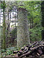
Chimney, Boringdon Tin Streamworks
Close to the stream running through Boringdon Wood.
Image: © Derek Harper
Taken: 28 Oct 2006
0.07 miles
2
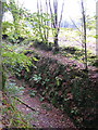
Cutting on line of Lee Moor Tramway
Precipitous drop for the unwary in Towers Wood. The tramway was built along a direct line through the wood, descending to Image - q.v. for more details. Beyond the cutting, a cleared area of woodland.
Image: © Derek Harper
Taken: 28 Oct 2006
0.15 miles
3
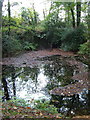
Lake in Boringdon Park Wood
Near the northern edge of the wood. I assume this is a flooded relic of Boringdon Park silver-lead mine, other remains of which are nearby in the wood.
Image: © Derek Harper
Taken: 28 Oct 2006
0.21 miles
4

Evidence of mining in Boringdon Park Wood
Beside the track along the south side of the wood.
Image: © Derek Harper
Taken: 28 Oct 2006
0.21 miles
6
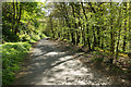
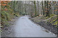
Plymbridge Woods
Looking along the former railway, now a cycle and walking trail, towards Plym Bridge. The woodland is in National Trust ownership.
Image: © Stephen McKay
Taken: 29 Apr 2017
0.22 miles
7
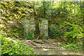
Building remains, Plymbridge Woods
There is not much left of this building, probably a platelayer's hut, next to the old railway through the woods although the remains of a fireplace can be discerned.
Image: © Stephen McKay
Taken: 29 Apr 2017
0.23 miles
8
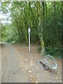
Bird sculpture and sculpted seat by the West Devon Way
Image: © David Smith
Taken: 22 Sep 2020
0.23 miles
9
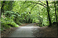
Sparkwell: West Devon Way
On the formation of the Plymouth-Tavistock railway, near Plym Bridge. This is also known as the Plym Valley Trail, part of a cycle route linking Ilfracombe on Devon's north coast, with Plymouth, on the English Channel. The Plym Valley Trail runs - in 2011 - from Clearbrook to Saltram House
Image: © Martin Bodman
Taken: 25 Aug 2011
0.23 miles
10
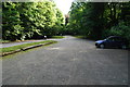
Car Park
This is the car park at Plym bridge,looking N.East towards the bridge.
Image: © jeff collins
Taken: 21 Jun 2009
0.23 miles