IMAGES TAKEN NEAR TO
Trelawny Road, PLYMOUTH, PL7 4LJ
Introduction
This page details the photographs taken nearby to Trelawny Road, PL7 4LJ by members of the Geograph project.
The Geograph project started in 2005 with the aim of publishing, organising and preserving representative images for every square kilometre of Great Britain, Ireland and the Isle of Man.

There are currently over 7.5m images from over14,400 individuals and you can help contribute to the project by visiting https://www.geograph.org.uk
Image Map (Loading...)


Getting Data...Please wait
Leaflet Map data © OpenStreetMap
Images are licensed for reuse under creativecommons.org/licenses/by-sa/2.0
Notes
- Clicking on the map will re-center to the selected point.
- The higher the marker number, the further away the image location is from the centre of the postcode.
Image Listing (9 Images Found)
Images are licensed for reuse under creativecommons.org/licenses/by-sa/2.0
Image
Details
Distance
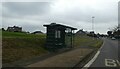
1
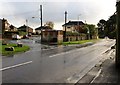
Plymbridge Road, Plympton
At the junction with Lucas Lane (left), and just about to drop down into the valley of the Tory Brook / Long Brook.
Image: © Derek Harper
Taken: 5 Nov 2009
0.08 miles
2
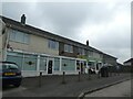
Row of shops, Plymbridge Road, Plympton
Image: © David Smith
Taken: 22 Sep 2020
0.08 miles
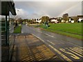
3
Plymbridge Road, Plympton
A view looking towards Plympton along Image, recently washed by a shower, and soon to get another one. On the left is a small parade of shops, with a mini-roundabout at the junction of Courtland Crescent beyond.
Image: © Derek Harper
Taken: 5 Nov 2009
0.08 miles
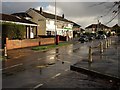
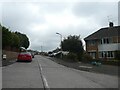
5
Plymbridge Road, Plympton
Coincidentally, I have selected the very same view as Image, although this one has a rainbow and an extra bus shelter. In the intervening years, the yellow bin, presumably for road salt, has vanished from the corner of Crossway.
Image: © Derek Harper
Taken: 5 Nov 2009
0.13 miles
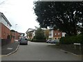
6
Revell Park Road, Plympton
A residential road whose surface has been laid in large blocks
Image: © David Smith
Taken: 22 Sep 2020
0.16 miles
7

Woodford, The Edge of Town
Modern housing on the edge of Plympton. Ahead, the road degrades into a single track country lane.
Image: © Tony Atkin
Taken: 12 Feb 2006
0.19 miles
8
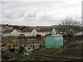
Acorn Gardens, off Plymbridge Road, Plympton
Image: © David Smith
Taken: 22 Sep 2020
0.19 miles