IMAGES TAKEN NEAR TO
Pode Drive, PLYMOUTH, PL7 2XZ
Introduction
This page details the photographs taken nearby to Pode Drive, PL7 2XZ by members of the Geograph project.
The Geograph project started in 2005 with the aim of publishing, organising and preserving representative images for every square kilometre of Great Britain, Ireland and the Isle of Man.

There are currently over 7.5m images from over14,400 individuals and you can help contribute to the project by visiting https://www.geograph.org.uk
Image Map
Images are licensed for reuse under creativecommons.org/licenses/by-sa/2.0
Notes
- Clicking on the map will re-center to the selected point.
- The higher the marker number, the further away the image location is from the centre of the postcode.
Image Listing (29 Images Found)
Images are licensed for reuse under creativecommons.org/licenses/by-sa/2.0
Image
Details
Distance
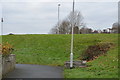
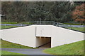
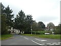
6
Bus stop on B3416, Glen Road
The access path from the left has come from an underpass linking housing estates on both sides of the busy road
Image: © David Smith
Taken: 22 Sep 2020
0.12 miles
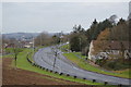
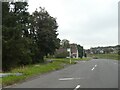
9
Evergreen trees, Clement Road, Chaddlewood
Image: © David Smith
Taken: 22 Sep 2020
0.13 miles
10
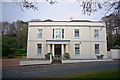
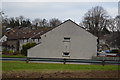
Chaddlewood House
This former mansion House was originally set in extensive parkland, which also contained Chaddlewood Farm. In recent times it was used as a prisoner of war camp during World War 2 and it is now divided into retirement apartments.
Image: © Nigel Mole
Taken: 25 Nov 2007
0.14 miles