IMAGES TAKEN NEAR TO
Tern Gardens, PLYMOUTH, PL7 2HZ
Introduction
This page details the photographs taken nearby to Tern Gardens, PL7 2HZ by members of the Geograph project.
The Geograph project started in 2005 with the aim of publishing, organising and preserving representative images for every square kilometre of Great Britain, Ireland and the Isle of Man.

There are currently over 7.5m images from over14,400 individuals and you can help contribute to the project by visiting https://www.geograph.org.uk
Image Map (Loading...)


Getting Data...Please wait
Leaflet Map data © OpenStreetMap
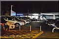
Images are licensed for reuse under creativecommons.org/licenses/by-sa/2.0
Notes
- Clicking on the map will re-center to the selected point.
- The higher the marker number, the further away the image location is from the centre of the postcode.
Image Listing (26 Images Found)
Images are licensed for reuse under creativecommons.org/licenses/by-sa/2.0
Image
Details
Distance
3
Thomas Pocklington Trust
Giving housing and support to people with sight loss. At the junction of George Lane and Ridgeway.
Image: © jeff collins
Taken: 10 Sep 2014
0.12 miles
4
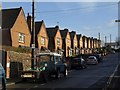
Elm Grove, Plympton
Twelve gables front the north side of this cul-de-sac, seen from Moorland Road.
Image: © Derek Harper
Taken: 10 Dec 2009
0.15 miles
5
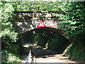
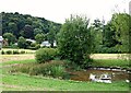
George Lane, Plympton
Whilst a large part of Plympton and Chaddlewood have been the subject of housing and industrial growth since the mid-1960s, the occasional reminder can be found of the origin 'stannary town'- this is the point where the GWR railway crosses George Lane, which used to run from the Ridgeway, through to the Cornwood/Sparkwell road.
Image: © Gwyn Jones
Taken: 15 Oct 2005
0.16 miles
6
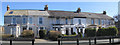
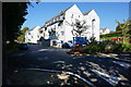
Regent Terrace or Villas
This terrace of properties features in a post card of around 1900 when the road name of Moorlane had some more significance than it has today. When constructed the residents would have had an uninterrupted view across to the edge of Dartmoor. Now the open grass land on the west side of Moorland Road has the Ridgeway Comprehensive School built over it which obscures the moorland view for those in Regent Terrace.
Regent Terrace was built by the successful brewer Samuel Vosper who had a brewery in Durnford Street, East Stonehouse in Plymouth. Sadly there is no reference in or around the terrace of houses to indicate its original name. Image
Image: © Colin Vosper
Taken: 10 Mar 2010
0.16 miles
7
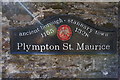
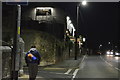
Sign on wall, Plympton St Maurice
On the side of a wall on George Lane.
Image: © jeff collins
Taken: 10 Sep 2014
0.17 miles
8
Pathfields, Plympton St Maurice, Devon
Pathfields, a large green space of 11 hectares, includes wildflower areas, a woodland, hedgerows and extensive fields. The area is managed jointly by the local council and the local Civic Association. In 2008, a Plympton conservation and management plan highlighted an intention to construct a pond within this particular area to create some wetland habitat and this has clearly been achieved. This field is used for occasional for community events, e.g. the summer fair. Elsewhere there is an unmetalled path crossing Pathfields from east to west, i.e. from Mudge Way to Barbican Road. The houses in the distance seem likely to be situated on minor 'estate roads' off The Ridgeway.
Image: © David Hallam-Jones
Taken: 18 Aug 2018
0.18 miles
9
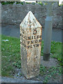
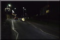
Old Milepost by the B3416, Manor Park Drive, Plymouth Parish
Cast iron post by the B3416 (was A38), in parish of PLYMOUTH (PLYMOUTH District), Plympton St Mary, Ridgeway, 30m West of Manor Park Close, close to road edge beside speed camera, on South side of road. Plymouth spear iron casting, erected by the Plymouth, Eastern turnpike trust in the 19th century.
Inscription reads:- : 5 / MILES / TO / PLYMo : : 5 / MILES / FROM / PLYMo :
Milestone Society National ID: DV_PLEX05.
Image: © Alan Rosevear
Taken: 15 Dec 2008
0.19 miles