IMAGES TAKEN NEAR TO
Taunton Avenue, PLYMOUTH, PL5 4HN
Introduction
This page details the photographs taken nearby to Taunton Avenue, PL5 4HN by members of the Geograph project.
The Geograph project started in 2005 with the aim of publishing, organising and preserving representative images for every square kilometre of Great Britain, Ireland and the Isle of Man.

There are currently over 7.5m images from over14,400 individuals and you can help contribute to the project by visiting https://www.geograph.org.uk
Image Map
Images are licensed for reuse under creativecommons.org/licenses/by-sa/2.0
Notes
- Clicking on the map will re-center to the selected point.
- The higher the marker number, the further away the image location is from the centre of the postcode.
Image Listing (23 Images Found)
Images are licensed for reuse under creativecommons.org/licenses/by-sa/2.0
Image
Details
Distance
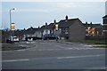
6
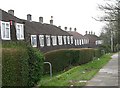
Postwar housing, Whitleigh
These are typical of the houses originally built on the Whitleigh Estate.
Image: © Tony Atkin
Taken: 7 Jan 2006
0.10 miles
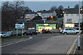
8
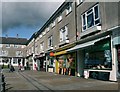
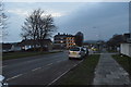
Whitleigh Green Shopping Precinct Plymouth
A small shopping precinct on what was once a 'council' estate now having a proportion of privately owned homes. Included in the estate plan to meet the day to day needs of residents but now serves largely to meet their emergency needs and the day to day needs of those who haven't the transport or capacity to shop elsewhere. Inevitably the precinct houses a fish and chip shop! Prices in such precincts are invariably higher than in the large out of town supermarkets which leads to their gradual decline as evidenced by one or two of these being boarded up, though local vandalism also plays its part. Upper floors of the shops contain flats.
Image: © Mick Lobb
Taken: 2 Oct 2008
0.12 miles
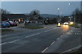
9
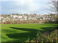
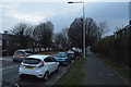
View of Whitleigh
Looking north from the Crownhill Road on a bright December morning.
A playground can be seen in the park at the bottom of the hill.
Image: © Jonathan Billinger
Taken: 10 Dec 2008
0.12 miles