IMAGES TAKEN NEAR TO
Carew Avenue, PLYMOUTH, PL5 3PA
Introduction
This page details the photographs taken nearby to Carew Avenue, PL5 3PA by members of the Geograph project.
The Geograph project started in 2005 with the aim of publishing, organising and preserving representative images for every square kilometre of Great Britain, Ireland and the Isle of Man.

There are currently over 7.5m images from over14,400 individuals and you can help contribute to the project by visiting https://www.geograph.org.uk
Image Map
Images are licensed for reuse under creativecommons.org/licenses/by-sa/2.0
Notes
- Clicking on the map will re-center to the selected point.
- The higher the marker number, the further away the image location is from the centre of the postcode.
Image Listing (31 Images Found)
Images are licensed for reuse under creativecommons.org/licenses/by-sa/2.0
Image
Details
Distance
1
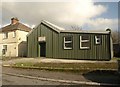
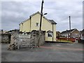
Honicknowle Reading and Recreation Hall
"Established 1927", reads the sign on this tin building, mapped as a "hall and Sunday School", on Butt Park Road, although an entry on the Plymouth Archives gives a date of 1911 of a "temporary portable corrugated iron reading and recreation room" (architect Edwin Evans) on Warwick Park Gardens. Warwick Park itself survives as a nursing home further down the road.
Image: © Derek Harper
Taken: 19 Feb 2011
0.03 miles
2
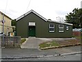
Honicknowle Reading and Recreation Hall
In Butt Park Road. a community building
Image: © David Smith
Taken: 26 Sep 2014
0.03 miles
3
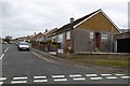
Bungalows, Carew Avenue, Honicknowle, Plymouth
Image: © David Smith
Taken: 26 Sep 2014
0.05 miles
5
An old stone wall and modern development, Carew Avenue
Image: © David Smith
Taken: 26 Sep 2014
0.05 miles
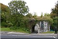
6
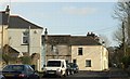
The end of Carew Avenue, Honicknowle
This is Carew Avenue, even though the sign on the wall reads "Cul-de-sac". On the left is the gateway to a nursing home
Image: © David Smith
Taken: 26 Sep 2014
0.05 miles
7
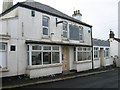
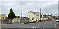
Butt Park Road, Plymouth
Butt Park Road, in the foreground, bends sharply left at the terrace in the centre; Dickemoor Lane continues on the right, the terrace facing the grounds of the new Shakespeare Primary School.
Image: © Derek Harper
Taken: 19 Feb 2011
0.07 miles
8
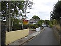
Horsham Lane, Honicknowle, Plymouth
A narrow cul-de-sac with old houses on the left, a primary school beyond the stone wall on the right and modern houses beyond. Formerly this was a lane giving access to fields
Image: © David Smith
Taken: 26 Sep 2014
0.09 miles
9
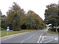
Autumn colour in Crownhill Road, Plymouth
Image: © David Smith
Taken: 26 Sep 2014
0.09 miles
10
The entrance to Woodland Fort
This was one of Palmerston's Forts (or Follies) built to protect Plymouth when there was a vague threat of a French invasion under Napoleon III
Image: © David Smith
Taken: 26 Sep 2014
0.10 miles